Category Archives: Troy’s Blog

Climbing Longs–Continue On or Not?

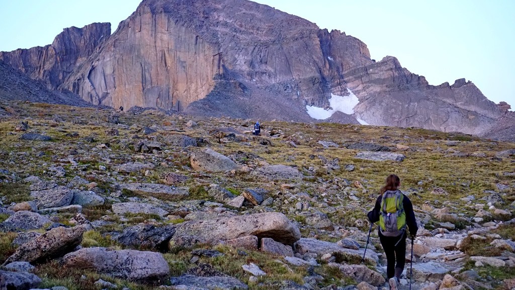
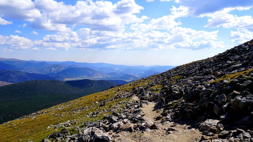
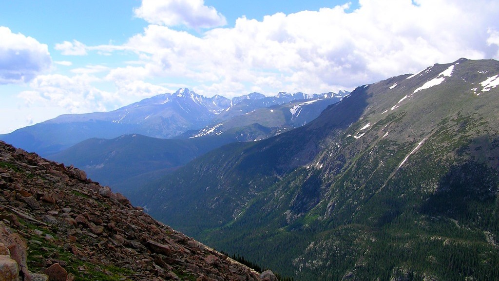
While taking in the views sitting in the Keyhole, Lysa and I discussed the next portion. Are we up for the next portion of this hike, which becomes a climb, and is considered more difficult than what we just completed. Our initial decision was to sit and enjoy our surroundings and return to the trailhead while the weather was in our favor as storms were predicted for the entire afternoon and clouds were beginning to form. You can see in the above picture of the next portion of our hike. There is a group following the trail towards a valley called the trough. Actually the trail looks fun except for one issue – being able to breath adequately at 13,000 feet. Going beyond the Keyhole the hike becomes increasingly more dangerous as a wrong step on parts of the trail can lead to serious injury and even death as has happened here before.

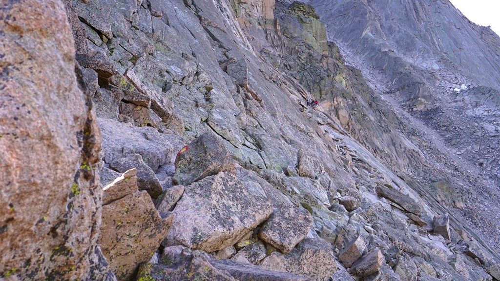
Sitting and enjoying the awesome surroundings while watching others maneuvering the trail was nice but a feeling kept burrowing deeper inside us. What’s it like on this trail and what’s around the corner that we can’t see? Well there really is only one way to find out! On went the packs as we moved to boulders making up the trail which is marked by red and yellow bulls eyes. The morning sun was warming us at the Keyhole but as we began this portion it was in the shadows with colder temperatures. Thankfully we had gloves as the boulders are quite cold up here. The trail wasn’t too difficult as long as you take your time and watch your step while grabbing boulders to maintain balance and support among this unforgiving granite.

Making our way to the Trough in the background

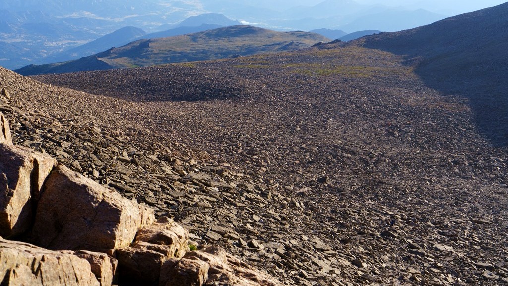
Time flew by as we slowly made our way up and over numerous rocks towards the valley called the Trough. There are a few challenging boulders to climb over but for the most part it was a nice climb/hike. Reaching the trough fatigue was beginning to set in.  This is concerning because it can lead to poor decision making in a place intolerable to it. Even though we took a few breaks along the way we needed to stop for a longer period of time to regain our oxygen levels and leg strength before the next section which requires continually climbing up.

Clouds continued to build around the mountains causing us to try and push towards the top so we began climbing the Trough as quickly as possible. About a third of the way up we began to get light headed and dizzy at times along with trembling legs. At this point we knew we had to slow down and take more breaks in order to get enough oxygen to continue our climb. After this point we would climb about 10 or 15 feet up and take a short break. That seemed to help maintain our strength but slowed down our climb. While we were climbing up there were others working their way down sliding from time to time making us realize up may actually be safer than coming back down. Occasionally a rock would come flying down towards us from other hikers above requiring us to take cover from time to time until the rock passed without incident. Eventually we picked our way through the rocks getting close to the top of the Trough reaching, what at first glance, was an impassible boulder. Taking some time to study our options we chose a path and nervously worked our way up and over this boulder and arrived what felt like on top of the world. There’s a geological marker here stating that we had made it to 13, 749 feet. Only 500 feet left to the top of Longs.

Climbing the Trough

We sat on a narrow strip of granite taking in our surroundings and resting after this energy draining climb up the Trough in preparation for the next section. Again the discussion arose of continuing towards the summit or not. After a few minutes we came to the conclusion it was time to call it a day and turn around. There were multiple reasons for this. First, clouds were continuing to get darker and there were obvious rain showers in the distance working towards us. Next, we had someone picking us up from the trailhead at a designated time and looking at the current time we were already going to be pushing that time. Finally we were very fatigued and still needed to climb down these difficult sections safely. I estimated we would need another 2 hours in order to make it to the summit and begin our descent which I was not interested in doing in thunderstorms with wet, slippery rock. Especially with my daughter.

The view from the top of the Trough

After taking some additional time enjoying the view, eating and drinking to replenish, and resting to re-gain strength, and talk with other hikers about the situation we began the climb down scrambling around this almost impossible boulder while others tried to figure out their way around it climbing up. With their assistance we made it down safely over this boulder and continued down the Trough making our way to the Keyhole once again. It felt good to be back to this point safely before any rain started to fall. Taking the last few minutes at this altitude we surveyed the area as it’s so incredible knowing we will not likely be back here again in our lifetime.

Taking in the views

Shortly we made our way down to the Boulder Field campground feeling good about what we accomplished and that it’s all down hill on relatively easy trails from here just as thunder began rumbling off in the distance. Better get moving in an attempt to reach the tree line before storms reach us. We didn’t make it far before thunder began to boom overhead bringing with it a rain/snow mix which we hiked in for the next couple of hours. Fortunately there wasn’t visible lightning striking the mountains allowing us to continue our hike instead of seeking out a depression along the trail to take cover in. Yes, the decision to forgo reaching the summit now seemed like a good call as we would have been caught somewhere above the keyhole on wet boulders or possibly snow as the mountain peaks around us were turning white making the hike even more dangerous and time consuming. The rain passed as we reached the tree line with only a few more miles to go before meeting our ride and the end of this adventure filled and tiring day.

Approaching rain/snow and storms

The return brought us down over 6 miles almost without stopping in an attempt to reach safety with storms expected much of the afternoon and then to reach the car. Because of this our legs became increasingly more sore with each step down we had to take. If we would have taken a few breaks to rest we would have been in good shape having accomplished an amazing hike.


Climbing Longs–The Keyhole

Now at the Boulder Field Campsite we were able to take in some of the surroundings, enjoy a little camaraderie with other hikers attempting to do the same thing, and use toilets in preparation for the next portion of our morning hike. (To catch up with our journey thus far click here to read the previous story.) It was noticeable how much colder the air was here. Even though we were almost the same elevation as the top of Flattop Mountain it seemed much colder to the point of being able to see our breath from time to time. Fortunately the sun was quickly warming us up. While studying the boulder field it became obvious that these boulders filled in the keyhole and more at one time. What natural event occurred causing this part of the mountain to crumble forcing all these large pieces of rock to fall making a river of boulders and leaving this keyhole? Was it ice, an earthquake, or something else?

Looking up at the boulders to be climbed to reach the Keyhole

As I scanned around I kept wondering how can the remaining portion of this hike to the summit be all that difficult? It didn’t appear to be all that long distance wise or a great elevation change from the boulder field. Of course elevation is a major factor for those of us not use to it. After 15 minutes or so we decided to continue on towards the Keyhole. There were several other hikers that climbed up ahead of us providing information on the climb we were about to do. Watching from a little distance it appeared they were going up fairly slow and taking their time. I’ve climbed over rocks before and it doesn’t take that long to continue upward.

A marmot coming to be pet with a hiker in the background climbing boulders

We decided to pack our trekking poles away as they weren’t likely to be much help on the boulder terrain and lifted the packs back onto our backs ready to continue. For this section of the hike on Longs you are basically boulder hopping. Stepping towards the next boulder hoping it’s stable while making your way increasingly higher. At least that’s the plan as it’s easy to just stay at your current altitude and just go sideways if not paying attention. Quickly you begin to realize the altitude makes things increasingly difficult simply because the thinner air causes problems getting enough oxygen to breath normally. It feels like you are running and out of breath after a short time slowing down the pace. Now it makes sense why the hikers ahead of us appeared to go so slowly up into the keyhole. In addition, the higher you go the larger the boulders get and the steeper the incline gets. Looking at the photo above you see a marmot that seemed to want to get pet. In the background is a good comparison of the boulder size next to a hiker.

Exploring the vaille

Getting closer to the keyhole we reached the Agnes Wolcott Vaille built as a place of protection from storms for those attempting to reach the top of Longs Peak. Finally almost there! A few minutes exploring this shelter and it was to the keyhole to view out over the Rocky Mountains. We’ve reached the main goal of this adventure – the Keyhole!

One of the views from the other side of the keyhole

Many hikers ahead of us proclaimed the amazing views while perched among the slim layer of rocks forming this keyhole continuing to encourage those below to reach it. They were right about the incredible views sitting in this unique rock formation. From both sides of the keyhole the landscape humbled us with its beauty and vastness. We felt so small among these huge boulders forming large mountains. It seemed to take forever to climb from the campground into the keyhole but according to the timestamps on the photos taken it only took us about 20 minutes or so to complete. While sitting in the keyhole eating a Clifbar and drinking more water we examined the next portion of trail that would take us to the summit of Longs Peak if we felt up to the challenge. I think the expression on Lysa’s face in the picture below gives a good idea of our thoughts! To continue on click here…..

Sitting in the Keyhole studying the next portion of the trail

Climbing Longs–Getting There

Our journey towards Longs Peak began at 2:30 am. That’s 2:30 am at the trailhead! We were not the first ones there at this time of day as this is a relatively busy trail in the summer but you must start early because it is a long and challenging trail with rain/snow/thunderstorms possible during the afternoon. We began the trail half asleep and unsure of what lay ahead but there were several others here in the same situation so up we we go. Surprisingly it was quite warm at almost 60 degrees F at the start of the trail. I was expecting temperatures in the 40’s during this time of night so off came the jacket before even starting as 60 degrees F is very warm for this strenuous of hiking.

Getting ready to hike to Longs

The entire trail to the summit of Longs Peak using the Keyhole Route is about 7.5 miles long each way with most of that trail needed just to get to the Keyhole. This takes you from the trailhead, up through the trees before reaching the alpine environment above the tree line, and around Mount Lady Washington. Hiking this distance on easier terrain is not terribly difficult for me and I’ve been preparing for this for several months, as you can read here, however this is continually hiking up, often time over steps, rocks, and tree roots, at a fairly steep incline. Even at that, the hiking was not as challenging as I expected which was a nice surprise. The difficulty came with the altitude. Above 10,000 feet, breathing becomes more difficult for me slowing down the pace in order to get adequate oxygen to continue on.

Longs_Peak_map

As we reached the tree line and began hiking in the tundra we got our first view of Longs Peak from closer up. It was a beautiful moonlit morning with the full moon hovering just above the mountain giving us a perfect outline of where we were headed.

Hopefully this is making sense because there are thunderstorms with a lot of lightning as I’m writing this causing distractions.

We took a few minutes to rest and enjoy the surroundings. It was fun to see all of the little lights bobbing along the trail both ahead of us and behind us. Like a little hiker road. While taking this photo the camera low battery symbol began to flash and I realized I forgot extra batteries for this camera and didn’t charge the batteries for the GoPro so taking a lot of pictures was out. This bummed me out because when am I likely to be here doing this again? After coming to terms with my lack of picture taking ability we moved on around Mount Lady Washington.

The first view of Longs Peak with a full moon just above

Almost around Mount Lady Washington and to the boulder field, the sun began to cress the horizon giving us an amazing sunrise way up on the mountain. A sight I hoped to see since preparing for this hike. It took my breath away! Maybe that was just the altitude while hiking. At this point people had created a relatively smooth trail placing stones together to create a sort of sidewalk making it more of a walk than a hike for a little distance. What a nice reprieve from steps and stones! Thank you to whomever did this.

With the sun rising we got our first good look at the mountain we were aiming to climb which is the main photo above. Surprisingly it didn’t look as insurmountable from here as it did from Flattop Mountain and other areas around Rocky Mountain National Park. We’ll see if that stays the case once we get there. Off towards the right I could see the Keyhole which has been the first goal of this hike. Anything after that would be a bonus. A short time later we arrived at the Boulder Field Campground and took a much needed rest before climbing up into the Keyhole. Yes, there really is a campground up here.

It took us about 5 hours to reach the campground and we traveled about 6 miles to this point. Feeling the strenuous hike it felt nice to sit for a little while and take in the views while mentally preparing for the next part. In my research it was said that this is the easy part of climbing Longs Peak. It didn’t seem all that easy to me! What are we in for next? To read more click here…..

Sunrise on the mountain

Egrets

This summer has provided some great opportunities to observe egrets and take a few pictures along the way. They are challenging to photograph in the blaring sun due to their pure white feathers but I still enjoyed the experience.

Got one!

For most of the time they were looking for food which brought entertainment as they strolled through the shallow water. It was interesting to listen to their calls and see their actions towards other egrets, heron, and ducks. Unfortunately I was unable to get a good picture of most of these interactions. They really didn’t seem to care about the ducks but herons and other egrets seemed to bring more aggression.

Looking for lunch

When not looking for food they would find a stump or branch to rest in and preen for several minutes. They didn’t seem to stay in one place very long requiring me to stay on top of the camera settings if I wanted decent shots along the way.

Taking in the sun

On occasion there would be multiple egrets together but that usually ended in squawking with one or more birds leaving that spot in search of a bit more solitude. The fishing must have been pretty good to bring several together. Did they realize there were multiple birds there or were they distracted by the search for food and then realized they weren’t alone?

Too many birds in one spot

As they day neared the end, egrets continued to hunt for every bit of food they could find before nightfall. Slowly stalking whatever moves under the surface of the calm, warm water. I enjoyed being able to watch as they went about their prowl and snap a few pictures here and there.

Looking for an evening snack


Another Lake Michigan Labor Day

A year ago I was visiting a friend in Michigan and decided to venture to a beach along Lake Michigan for the afternoon of Labor Day weekend. Surprisingly a year later I’m back doing the same thing only this time from the Illinois side. We met friends for Labor Day weekend in Chicago to explore some of the city sites.

Downtown Chicago

After taking in a drive-in movie, an American tradition that is unfortunately losing popularity, we arrived back at our hotel early the next morning. We awoke, grabbed some breakfast, and drove downtown somewhat sleep deprived to visit Shedds Aquarium and spend the afternoon on the beach before getting some authentic Chicago style pizza.  At least that was the plan in our sleep stupor.

Walking along the Chicago River

Before leaving the hotel we quick checked ticket information for the aquarium and found a $15 service fee added to each ticket to buy online for that day. Opting the stand in line for tickets we sped off towards downtown Chicago to the lake front and Shedds Aquarium. After some time wrestling with traffic we arrived at Soldier Field to park for the day and hiked the short distance to Shedds.

The view of downtown while waiting in line at Shedds

Arriving at the entrance we saw the line that has formed to gain entrance into this well known destination. Following that line further and further back we realized the hike was not quite over. Amazing how long of a line for entrance into an aquarium. I’ve never witnessed a wait like this for fish before. After almost three hours in line we made it to the ticket counter. While standing in line with the afternoon slipping by we discussed purchasing tickets for the next day as the time left in this day was likely not enough to see everything desired. Asking about this option we were informed they could not sell tickets for the next day but we could purchase them online for the same amount as long as we bought them before tomorrow.

Chicago's lake front heading towards Navy Pier

While grabbing a seat and some ice cream we decided to purchase tickets using our phones for the next day and what do you know? There was no $15 service fee. Had we only known that before today all of this waiting in line would have been avoided. Now that the aquarium was out of the plans for this day we opted to walk the Magnificent Mile and see the sights of downtown. From the aquarium we headed towards Navy Pier along the shore of Lake Michigan, turned at the famous Chicago River and headed a few blocks into downtown enjoying the riverfront development which is much improved from just a few years ago.

The famous Bean sculpture in Millennium Park

Once at Michigan Avenue we headed back towards the aquarium passing several street performers before stopping at Millennium Park to see the Bean and listen to some jazz in the amphitheater as there was a jazz festival taking place for the weekend. Every time I’ve looked over a picture of the famous Bean I’ve always thought is was kind of stupid. This polished metal bean sitting near the waterfront of downtown Chicago. I never really understood the interest in it. Seeing it in person I enjoyed watching all of these people excited over the different ways the Bean warps your reflection and the reflection of the city. This made it more interesting and fun to see and now I have a better appreciation for it. Fireworks from Navy Pier

Our day ended with a Chicago style pizza and the last fireworks show from Navy Pier for the summer. A beautiful night for fireworks but yet another late evening returning to the hotel for some much needed rest before waking early again the next day for another attempt and Shedds Aquarium.

Pacific White-sided Dolphins peaking over the railing

Armed with already purchased tickets we entered Shedds the next day without having to wait in line. If you’re ever planning on going and seeing everything in the aquarium, I highly recommend getting tickets online at least a day ahead of time. It could save a lot of time standing around viewing the city skyline. They have one of the best aquatic shows which include beluga whales and Pacific white-sided dolphins that I’ve seen. There was also a stingray petting tank which is seasonal. Overall we spent over 6 hours taking in the exhibits and shows enjoying many different displays.

Enjoying the beach on Lake Michigan near Adler Planatarium

This day ended with a stop at a nearby beach to take in the waves of Lake Michigan on a beautiful Chicago afternoon. Ohh, and for lunch it was Chicago style hotdogs. How could I forget about that? There is so much more to see but we had a nice time for a Lake Michigan Labor Day! Will there be another one next year?


Exploring Flattop Mountain

Back in 2009 we visited Rocky Mountain National Park to hike to Flattop Mountain Trail and we did that successfully. Unfortunately that was done after a long day of exploring so there wasn’t much energy to continue further. I’ve wanted to attempt the trail again if the opportunity presented itself. Well, recently we made the opportunity happen and once again found ourselves on the trail. Surprisingly the beginning of the trail looks very different from what it looked like seven years ago as proven in the next two photos.

Flattop Trail in 2009

Flattop Trail in 2016

The top picture was taken in 2009 and the next one taken just a few weeks ago. I can find now similarities to them which made it a little challenging to begin this hike since there wasn’t really recognition of the beginning of the trail causing me to question if we were on the right path or not. Especially since it was still dark when we got to this point. Trusting in the trail signs we pressed onward towards the top.

Flattop Trail Head when we began our hike from Bear Lake

Our hike on Flattop Mountain began at 4:30am as we passed Bear Lake. The scene is pictured above. In the dark, armed with flashlights, our journey on this mountain trail began to climb towards to top. In a short time we began to see light on the horizon however the trail swallowed by trees continued to be dark requiring artificial light sources to make our way over rocks and tree roots as we went up, up, up, to the sky.

Sunrise from the mountain

As we continued on this trail we could begin to feel the effects of the ever thinning air making it more difficult to breath and hike at a fast pace. Increasing our breaks while we trekked higher the trees began to decrease in size indicating the approaching tree line where they can no longer grow in the cool mountain air. Daylight finally penetrated this forest trail just as we broke above the trees bringing spectacular views of the mountains surrounding us with Emerald lake in the valley below. Our climb began below this lake and now look how high above it we are. Progress.

Overlooking Emerald Lake

Marmots appeared from the rocks in the mountain to greet us as we passed their homes. They made for a more interesting hike once reaching the tundra of the alpine zone on Flattop Mountain. Watching as they climbed in and out of boulders and finally on top of them to grab the warmth of the morning sun before gathering food for the day was extremely entertaining.

Marmots came out to greet us

They would definitely not be outdone by their smaller tundra mates – the Picas. These smaller alpine mammals would give a sharp squeak but would not always come into view as they moved between the rocks and boulders. If you watched long enough there would be a glimpse of movement and out would come one of these soft Picas running across the surface as they gathered portions of plants to store in their nests giving another squeak as if to say good morning while we passed.

Picas roaming around on the tundra

After several hours of hiking and a number of breaks to catch our breath we reached the summit of Flattop Mountain. I always imagine mountains as these immovable pieces of solid stone reaching towards to sky. It surprises me as we walk the top of the mountain that the top is scattered stones and boulders showing they are not as solid as originally perceived. The elements continue to work on these mountains breaking them apart slowly over time. For now it’s a great challenge to climb to the top of these massive rock formations.

Reaching the top of Flattop Mountain

In our picture above you see Hallet Peak to the right which is the next mountain over and one we briefly discussed climbing but decided this was enough for today as the real  challenge rests in the left of this photo – Longs Peak. A hike for another day. With our goal achieved for today we spent some time exploring and taking in the sights of our amazing surroundings, and watching some of the animals as they went about their business for the day.

One of the vast views from up here

After a little rest and energizing food we ventured to the nearby Continental Divide Trail. I’ve read about people hiking this entire trail covering over 3,000 miles from Mexico to Canada and wanted to walk a little of this beautiful trail. There were large cairns marking the trail most likely to show where it is during the spring and fall when snow could cover it making a more challenging hike and increased likelihood of getting lost. Further exploration on the CDT was tempting but it was time to head back down the mountain. With our destination successfully found we began the descent back to Bear Lake.

Exploring the Continental Divide Trail


Scott’s Bluff

Sounds like a high stakes card game doesn’t it. In this case it’s Scotts Bluff National Monument named after Hiram Scott who died here. While driving through the plains and fields of Nebraska for a significant time the landscape begins to become a little monotonous making any change stand out. In the panhandle of Nebraska lies these beautiful white bluffs. Kind of an entrance to the mountainous terrain of the Rocky Mountains.

The bluffs at Scotts Bluff National Monument

Our family was on our way to Colorado to explore these mountains and stopped near Scotts Bluff National Monument for the night so decided to learn more about the significance of this national park. It was a beautiful sunny Midwestern late afternoon with temperatures hovering around 90 degrees Fahrenheit and a gentle breeze to keep us cool.

There are 3 tunnels through the bluff taking you to the top.

The first stop was in the Visitor’s Center to pay our entrance fee and learn more about the significance of the area. In this place passed several important trails in history including the Oregon Trail, Mormon Trail, California Trail, and a Pony Express route for a short time. While these are all significant pieces in United States history, the Oregon Trail was the portion that intrigued me the most. I don’t know if it’s simply because the first computer game I played was called Oregon Trail on an Apple computer or because of the historical significance of people migrating west on this long and difficult trail.

Sun moving closer to the horizon behind the bluffs

After this educational stop we progressed to the Summit Road leading to beautiful views on top of the bluffs. Once at the top we took about an hour to hike around the top looking at different views which enhanced all that was recently learned in the Visitor’s Center as well as just enjoying the landscape from this vantage point. As we finished taking in the sights on the bluff we decided a trip to check in at our hotel nearby and refresh after a long day of travel was in order along with dinner before returning to walk along the Oregon Trail as sunset engulfed the horizon.

Walking along the wagons of the Oregon Trail

As the air began to cool and the sun relented it’s midday power we returned to find the park shutting down for the day with only the parking lot left open to explore the Oregon Trail. A very humbling experience to walk along these wagons depicting the horse and ox drawn trains of people and all their belongings attempting to find a better life in the west. Difficult to imagine traveling about 20 miles a day and having to obtain food, water, and shelter each night for the many months it took to reach the western destinations. Certainly an evening such as this was one of the easier days to make this trip but these types of nights only lasted a few months. Not long enough to complete their journey.

Sunset over the Prairie

What a beautiful way to end another day along our journey west!


The Infamous Corn Palace.

On a recent road trip in the upper Midwest we had the privilege of staying in Mitchell, South Dakota and of course we had to see this years version of the Corn Palace. The theme was “Rock of Ages” and was almost complete at the time of our visit. On the front of the building there is a picture of a guitarist and Willie Nelson constructed out of pieces of grain. Moving around the building there is a mural of Elvis, a singer, piano, person playing guitar, singers, and dancers to finish off the adjacent wall.

The adjacent wall murals

Most of the lighter portions are created using corn cobs along with wheat stems bundled together and sorghum stems bundled together created to give a darker contrast all working together to form these giant pieces of art. This is a very time consuming and laborious process which they undertake every summer creating a new theme covering two sides of the building.

Area set up for creating the pieces of each mural

This marks the third time I’ve been to this popular attraction. The last time was about 6 years ago with my first visit occurring a little over 7 years ago on my first trip to South Dakota. One of the surprises for me this summer was the change in domes on top of the building. Previous domes where solid and painted yellow and green that I remember. I like the new ones better.

The new domes and balcony

More modern and interesting allowing light to play off of the metal creating some nice effects. We didn’t see it at night but from pictures I searched the Corn Palace lights up beautifully with the new metal domes. Another nice addition since I last visited was a second floor balcony allowing more light inside due to large windows and the ability to walk outside on a nice day such as the one we visited on.


Preparing for a Rocky Mountain Hike

Since exploring Rocky Mountain National Park in 2009 I’ve wanted to return as it is such a beautiful place. Our last trip was to hike to Flattop Mountain Trail which is the location on our National Parks Monopoly Board. In 2009 we made it to the sign and returned to the car. I’ve always felt that I would like to hike the trail in its entirety someday.

Flattop Mountain Trail

That someday will happen this summer. Or at least we are going to be back in the park and hopefully the weather cooperates allowing me to hike to the top of Flattop Mountain which is a 10 mile hike round trip. Typically 10 miles isn’t a concern for me but it gets a little more difficult with the incline/decline and altitude in a mountain setting. Flattop peaks at just over 12,000 feet altitude and while this has an impact on me it wasn’t very bad the last time I was at this height.

Look at the beautiful surroundings

In addition to Flattop Mountain I’ve added in the challenge of hiking to the top of Long’s Peak which is a 15 mile trip and tops out just over 14,000 feet in altitude. A few years ago I would have never considered doing this as I’m not in physical condition to do so. After reading a few long distance hiker’s blog I began to consider it and figure out what it would take for me to do.  The idea of hiking to the top of the tallest peak in Rocky Mountain National Park, which I’ve looked at from an airplane, and see it from the other direction is a challenge I want to take on.

In order to be successful at these hikes I’ve been in training since January to build my legs and also try and increase my lung capacity as much as possible to prepare for the thinner air at higher altitudes. This training has included hiking several miles at a time carrying a 45 pound training pack which is at least double the weight of what my actual backpack will be. Hopefully the actual pack will feel quite a bit lighter so I don’t mind carrying it for a much longer distance. The training pack also put a heavier load on my legs building those muscles a bit more.

One of my practice hiking trails

Additionally I’ve been working with inline skates and biking with the occasional walking up and down stairs for 45 – 60 minutes with a loaded backpack on. Some days have been more challenging than other to go work out just like it is for anybody. In January I would go out on the trail even at temperatures of –12 degrees F and in the summer heat and humidity when I would return home so full of sweat I looked as though I had jumped into a lake. During these time I just needed to think about climbing mountain trails and my motivation would quickly return and I could walk faster or pedal harder forgetting about the conditions I was training in.

Biking on the trail

The time has come to see if all of that training will pay off in the form of an easier and successful hike. Certainly some of the mountain trails, especially near the top of Long’s Peak, have been a little intimidating but I’ve seen enough video and photos of the trail and have enough confidence in my abilities that as long as the weather remains favorable I’ll make it to the top.  If the weather does not cooperate than the risk does not become worth the reward of summiting Long’s Peak and I will turn around which is why the planned start time is around 2:30am to increase the odds of completing my goals. It’ll be fun either way I’m sure as there is nothing but amazing scenery all around.


Great Blue Herons

Ever since taking the photo below of a relatively close up of a Great Blue Heron I’ve wanted to find an opportunity to do so again once I upgraded cameras to the Sony mirrorless NEX-F3.

Great Blue Heron on Isle Royale

Unfortunately every time I seemed to be getting close for a nice picture of a heron it would get spooked and fly away all the while squawking at me eliminating any hope of capturing an image. This summer I found a couple of opportunities for photographs. While learning how to become a part of the landscape for hunting purposes, these skills were not adequate for pictures of this somewhat elusive bird. Keep in mind I have limited distance with my zoom lenses as the bigger ones require a fair amount of money which I am unwilling to spend as this is just a hobby. However I found a larger lens for relatively low expense by renting it for a couple of days at a time. The image below was taken with a 150-600mm telephoto lens which brings wildlife considerable closer than my little 210mm zoom lens.

Moving through the water

With that in mind, the photograph below was taken using my little 210mm lens. One of the skills I’m working on is hiding amongst my surroundings in order to achieve better results and it seems to be working. Of course finding the right location helps as well. The heron below was taken at a local lake frequented by such birds increasing my chances of getting closer to one. Here it is captured just as it spotted something moving in the water. Moments later it successfully caught something to eat.

What was that?

On the same lake but another location I caught this one sharing the area with a trumpeter swan and some ducks. I would like to have been closer but I still enjoy being able to photograph a heron before if flies away.

Sharing the lake with a swan and ducks

This next group of pictures were taken from a dock where the heron was obviously use to people being around making the potential for pictures easier. The next four photos are a sequence of a heron diving for food. In the photo below it saw something to strike at.

Spotted something

In the next picture the heron is leaping into the water attacking a potential meal where it was almost complete submerged for a time.

Diving in for food

Below is of the heron shaking water from its feathers after being soaked by the water. I couldn’t tell if it actually caught what it was after making its efforts worthwhile.

Drying off

Finally the heron is back standing on the log it began on to begin the search for food all over again.

Searching for food

My last image shows a heron with wings fully expanded as it takes off right in front of me in the evening sun. This particular heron flew away and returned to this same area multiple times over a few hours given the opportunity to practice photographing herons and learning how they act in this situation. I could identify this heron because of the feather or two missing from its left wing. For much of the time I was about 25 feet away from it just to give you an idea how close they have to be for a 210mm zoom lens to fill a frame with a heron. A very enjoyable time at the lake to spite the mosquitoes trying to distract me.

Flying Heron