Tag Archives: Longs Peak

Climbing Longs–A Reflection

A good gage for me of if I liked an experience is would I do it again. Would I hike/climb Longs Peak again? It depends on when you asked me. For a couple of weeks following I would’ve told you I was glad I did it but probably would not do it again. Asking a couple of months later I would definitely consider doing it again if the opportunity arose in the next couple of years. Maybe that’s me just being stupid and forgetting how strenuous the hike is even before getting to the keyhole and how difficult the thinner air above 10,000 feet makes this hike. Being stupid or not I know now what to be prepared for.

The amazing sunrise alone was worth the hike to this point

For 2 days following the hike to Longs Peak I had difficulty walking because of pain in my legs. Getting up from sitting and sitting back down were functions I lacked without assistance. I credit this to going 6 miles downhill at a fast pace without taking breaks allowing my legs to gain adequate oxygen while trying to avoid the surrounding storms. The other piece that took away from the enjoyment of this hike was difficulty in breathing for much of it. It felt like I was always gasping for air whenever I wanted to climb after passing the Boulder Field Campground. It would not have been as demoralizing if there wasn’t a timeline due to storms and my ride at the trailhead pre-scheduled without a means of contacting my ride to re-schedule allowing for more enjoyment of a slower pace. I was unsure of my abilities in these conditions so I had to estimate a pick up time which turned out to be too early in the afternoon.

One of the beautiful waterfalls we passed in the night on our way up Longs Peak

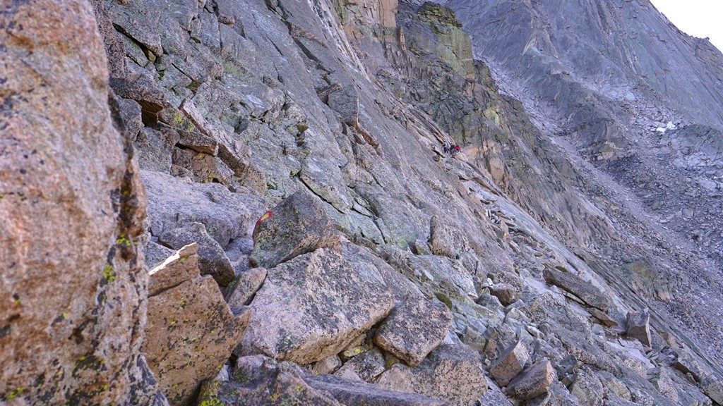
While on the mountain trying to decide if we should continue on from the Trough or not I kept trying to determine if I would regret not summiting if that was the decision we made. Well, it’s been a couple of months now and I do not regret our decision. For the conditions it was the right call for us. It likely would have taken us an additional 2 hours to summit and make it back to our position above the Trough. We would have gotten caught in increasingly difficult conditions due to storms in our descent increasing the risk of injury or worse. I wish the conditions would have allowed us to continue to summit but that just was not our situation. There is such a great respect for those that take on this climb after having done almost all of it.

One of the many views from the top of the Trough

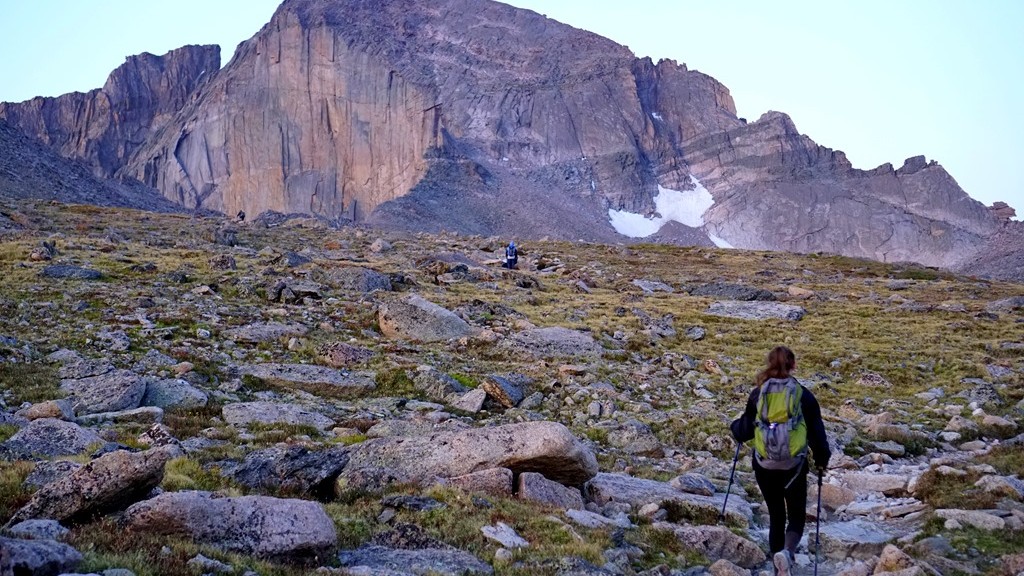
Upon completing this adventure I could not figure out how I felt about it. Was it worth all of the effort required to do it? I now feel a huge sense of accomplishment and satisfaction tackling Longs Peak. It was completely worth the work, pain, and dedication to climb this mountain. What an unbelievable experience and to have been able to share it with my oldest daughter is priceless. It would have been great to also share it with my youngest daughter but that would have been more than I could handle on my own given the risks involved above the Keyhole. The scenery was so beautiful and peaceful both on the way up in the serenity of a moon lit landscape and the way back down as the mountain tops turned white from the snow while we got rained on. It must have been a great accomplishment as I’m considering a hike to the top of Mauna Loa on our final Monopoly adventure to Hawaii Volcanoes National Park which surprisingly tops out at over 13,600 feet. Additionally I monitor the Longs Peak trail conditions and webcam having a more intimate relationship with this mountain now. I love adventures and this was an amazing one!

The Rocky Mountains from Longs Peak


Climbing Longs–Continue On or Not?

While taking in the views sitting in the Keyhole, Lysa and I discussed the next portion. Are we up for the next portion of this hike, which becomes a climb, and is considered more difficult than what we just completed. Our initial decision was to sit and enjoy our surroundings and return to the trailhead while the weather was in our favor as storms were predicted for the entire afternoon and clouds were beginning to form. You can see in the above picture of the next portion of our hike. There is a group following the trail towards a valley called the trough. Actually the trail looks fun except for one issue – being able to breath adequately at 13,000 feet. Going beyond the Keyhole the hike becomes increasingly more dangerous as a wrong step on parts of the trail can lead to serious injury and even death as has happened here before.

Sitting and enjoying the awesome surroundings while watching others maneuvering the trail was nice but a feeling kept burrowing deeper inside us. What’s it like on this trail and what’s around the corner that we can’t see? Well there really is only one way to find out! On went the packs as we moved to boulders making up the trail which is marked by red and yellow bulls eyes. The morning sun was warming us at the Keyhole but as we began this portion it was in the shadows with colder temperatures. Thankfully we had gloves as the boulders are quite cold up here. The trail wasn’t too difficult as long as you take your time and watch your step while grabbing boulders to maintain balance and support among this unforgiving granite.

Making our way to the Trough in the background

Time flew by as we slowly made our way up and over numerous rocks towards the valley called the Trough. There are a few challenging boulders to climb over but for the most part it was a nice climb/hike. Reaching the trough fatigue was beginning to set in.  This is concerning because it can lead to poor decision making in a place intolerable to it. Even though we took a few breaks along the way we needed to stop for a longer period of time to regain our oxygen levels and leg strength before the next section which requires continually climbing up.

Clouds continued to build around the mountains causing us to try and push towards the top so we began climbing the Trough as quickly as possible. About a third of the way up we began to get light headed and dizzy at times along with trembling legs. At this point we knew we had to slow down and take more breaks in order to get enough oxygen to continue our climb. After this point we would climb about 10 or 15 feet up and take a short break. That seemed to help maintain our strength but slowed down our climb. While we were climbing up there were others working their way down sliding from time to time making us realize up may actually be safer than coming back down. Occasionally a rock would come flying down towards us from other hikers above requiring us to take cover from time to time until the rock passed without incident. Eventually we picked our way through the rocks getting close to the top of the Trough reaching, what at first glance, was an impassible boulder. Taking some time to study our options we chose a path and nervously worked our way up and over this boulder and arrived what felt like on top of the world. There’s a geological marker here stating that we had made it to 13, 749 feet. Only 500 feet left to the top of Longs.

Climbing the Trough

We sat on a narrow strip of granite taking in our surroundings and resting after this energy draining climb up the Trough in preparation for the next section. Again the discussion arose of continuing towards the summit or not. After a few minutes we came to the conclusion it was time to call it a day and turn around. There were multiple reasons for this. First, clouds were continuing to get darker and there were obvious rain showers in the distance working towards us. Next, we had someone picking us up from the trailhead at a designated time and looking at the current time we were already going to be pushing that time. Finally we were very fatigued and still needed to climb down these difficult sections safely. I estimated we would need another 2 hours in order to make it to the summit and begin our descent which I was not interested in doing in thunderstorms with wet, slippery rock. Especially with my daughter.

The view from the top of the Trough

After taking some additional time enjoying the view, eating and drinking to replenish, and resting to re-gain strength, and talk with other hikers about the situation we began the climb down scrambling around this almost impossible boulder while others tried to figure out their way around it climbing up. With their assistance we made it down safely over this boulder and continued down the Trough making our way to the Keyhole once again. It felt good to be back to this point safely before any rain started to fall. Taking the last few minutes at this altitude we surveyed the area as it’s so incredible knowing we will not likely be back here again in our lifetime.

Taking in the views

Shortly we made our way down to the Boulder Field campground feeling good about what we accomplished and that it’s all down hill on relatively easy trails from here just as thunder began rumbling off in the distance. Better get moving in an attempt to reach the tree line before storms reach us. We didn’t make it far before thunder began to boom overhead bringing with it a rain/snow mix which we hiked in for the next couple of hours. Fortunately there wasn’t visible lightning striking the mountains allowing us to continue our hike instead of seeking out a depression along the trail to take cover in. Yes, the decision to forgo reaching the summit now seemed like a good call as we would have been caught somewhere above the keyhole on wet boulders or possibly snow as the mountain peaks around us were turning white making the hike even more dangerous and time consuming. The rain passed as we reached the tree line with only a few more miles to go before meeting our ride and the end of this adventure filled and tiring day.

Approaching rain/snow and storms

The return brought us down over 6 miles almost without stopping in an attempt to reach safety with storms expected much of the afternoon and then to reach the car. Because of this our legs became increasingly more sore with each step down we had to take. If we would have taken a few breaks to rest we would have been in good shape having accomplished an amazing hike.


Climbing Longs–The Keyhole

Now at the Boulder Field Campsite we were able to take in some of the surroundings, enjoy a little camaraderie with other hikers attempting to do the same thing, and use toilets in preparation for the next portion of our morning hike. (To catch up with our journey thus far click here to read the previous story.) It was noticeable how much colder the air was here. Even though we were almost the same elevation as the top of Flattop Mountain it seemed much colder to the point of being able to see our breath from time to time. Fortunately the sun was quickly warming us up. While studying the boulder field it became obvious that these boulders filled in the keyhole and more at one time. What natural event occurred causing this part of the mountain to crumble forcing all these large pieces of rock to fall making a river of boulders and leaving this keyhole? Was it ice, an earthquake, or something else?

Looking up at the boulders to be climbed to reach the Keyhole

As I scanned around I kept wondering how can the remaining portion of this hike to the summit be all that difficult? It didn’t appear to be all that long distance wise or a great elevation change from the boulder field. Of course elevation is a major factor for those of us not use to it. After 15 minutes or so we decided to continue on towards the Keyhole. There were several other hikers that climbed up ahead of us providing information on the climb we were about to do. Watching from a little distance it appeared they were going up fairly slow and taking their time. I’ve climbed over rocks before and it doesn’t take that long to continue upward.

A marmot coming to be pet with a hiker in the background climbing boulders

We decided to pack our trekking poles away as they weren’t likely to be much help on the boulder terrain and lifted the packs back onto our backs ready to continue. For this section of the hike on Longs you are basically boulder hopping. Stepping towards the next boulder hoping it’s stable while making your way increasingly higher. At least that’s the plan as it’s easy to just stay at your current altitude and just go sideways if not paying attention. Quickly you begin to realize the altitude makes things increasingly difficult simply because the thinner air causes problems getting enough oxygen to breath normally. It feels like you are running and out of breath after a short time slowing down the pace. Now it makes sense why the hikers ahead of us appeared to go so slowly up into the keyhole. In addition, the higher you go the larger the boulders get and the steeper the incline gets. Looking at the photo above you see a marmot that seemed to want to get pet. In the background is a good comparison of the boulder size next to a hiker.

Exploring the vaille

Getting closer to the keyhole we reached the Agnes Wolcott Vaille built as a place of protection from storms for those attempting to reach the top of Longs Peak. Finally almost there! A few minutes exploring this shelter and it was to the keyhole to view out over the Rocky Mountains. We’ve reached the main goal of this adventure – the Keyhole!

One of the views from the other side of the keyhole

Many hikers ahead of us proclaimed the amazing views while perched among the slim layer of rocks forming this keyhole continuing to encourage those below to reach it. They were right about the incredible views sitting in this unique rock formation. From both sides of the keyhole the landscape humbled us with its beauty and vastness. We felt so small among these huge boulders forming large mountains. It seemed to take forever to climb from the campground into the keyhole but according to the timestamps on the photos taken it only took us about 20 minutes or so to complete. While sitting in the keyhole eating a Clifbar and drinking more water we examined the next portion of trail that would take us to the summit of Longs Peak if we felt up to the challenge. I think the expression on Lysa’s face in the picture below gives a good idea of our thoughts! To continue on click here…..

Sitting in the Keyhole studying the next portion of the trail

Climbing Longs–Getting There

Our journey towards Longs Peak began at 2:30 am. That’s 2:30 am at the trailhead! We were not the first ones there at this time of day as this is a relatively busy trail in the summer but you must start early because it is a long and challenging trail with rain/snow/thunderstorms possible during the afternoon. We began the trail half asleep and unsure of what lay ahead but there were several others here in the same situation so up we we go. Surprisingly it was quite warm at almost 60 degrees F at the start of the trail. I was expecting temperatures in the 40’s during this time of night so off came the jacket before even starting as 60 degrees F is very warm for this strenuous of hiking.

Getting ready to hike to Longs

The entire trail to the summit of Longs Peak using the Keyhole Route is about 7.5 miles long each way with most of that trail needed just to get to the Keyhole. This takes you from the trailhead, up through the trees before reaching the alpine environment above the tree line, and around Mount Lady Washington. Hiking this distance on easier terrain is not terribly difficult for me and I’ve been preparing for this for several months, as you can read here, however this is continually hiking up, often time over steps, rocks, and tree roots, at a fairly steep incline. Even at that, the hiking was not as challenging as I expected which was a nice surprise. The difficulty came with the altitude. Above 10,000 feet, breathing becomes more difficult for me slowing down the pace in order to get adequate oxygen to continue on.

Longs_Peak_map

As we reached the tree line and began hiking in the tundra we got our first view of Longs Peak from closer up. It was a beautiful moonlit morning with the full moon hovering just above the mountain giving us a perfect outline of where we were headed.

Hopefully this is making sense because there are thunderstorms with a lot of lightning as I’m writing this causing distractions.

We took a few minutes to rest and enjoy the surroundings. It was fun to see all of the little lights bobbing along the trail both ahead of us and behind us. Like a little hiker road. While taking this photo the camera low battery symbol began to flash and I realized I forgot extra batteries for this camera and didn’t charge the batteries for the GoPro so taking a lot of pictures was out. This bummed me out because when am I likely to be here doing this again? After coming to terms with my lack of picture taking ability we moved on around Mount Lady Washington.

The first view of Longs Peak with a full moon just above

Almost around Mount Lady Washington and to the boulder field, the sun began to cress the horizon giving us an amazing sunrise way up on the mountain. A sight I hoped to see since preparing for this hike. It took my breath away! Maybe that was just the altitude while hiking. At this point people had created a relatively smooth trail placing stones together to create a sort of sidewalk making it more of a walk than a hike for a little distance. What a nice reprieve from steps and stones! Thank you to whomever did this.

With the sun rising we got our first good look at the mountain we were aiming to climb which is the main photo above. Surprisingly it didn’t look as insurmountable from here as it did from Flattop Mountain and other areas around Rocky Mountain National Park. We’ll see if that stays the case once we get there. Off towards the right I could see the Keyhole which has been the first goal of this hike. Anything after that would be a bonus. A short time later we arrived at the Boulder Field Campground and took a much needed rest before climbing up into the Keyhole. Yes, there really is a campground up here.

It took us about 5 hours to reach the campground and we traveled about 6 miles to this point. Feeling the strenuous hike it felt nice to sit for a little while and take in the views while mentally preparing for the next part. In my research it was said that this is the easy part of climbing Longs Peak. It didn’t seem all that easy to me! What are we in for next? To read more click here…..

Sunrise on the mountain