Earlier this spring my family took a road trip to the Central Michigan over Spring Break. On our way back home we wanted to do a little exploring in Pictured Rocks National Lakeshore. Rising at about the same time as the sun, we left the Traverse City area and headed north. Several hours later we once again reached the Mackinaw Bridge driving over it for a second time in only a few days looking out at Lake Michigan on one side and Lake Huron on the other. Continuing north in the Upper Peninsula of Michigan we arrived at Pictured Rocks and now had to figure out what we wanted to see there. Unfortunately the visitors centers were closed so all that were available were the maps they had put on display outside their visitors center and those on our phones. Our first hike was to see the Munising Falls near the visitor center which is a pretty little waterfall only a short hike from the nearby parking lot. The sun had broken out making it comfortable with only a sweatshirt on this early April morning. It was a nice hike as plants were beginning to come back to life after many months of rest during the winter surrounding the water flowing over these sandstone rocks.

Unfortunately the only camera I had now was the one on my phone since my other camera had died earlier in the trip, which you can read about in the previous article. Phone cameras do a nice job but they have limitations compared to better cameras with interchangeable lenses. Still I accepted this challenge to take interesting pictures with the camera available recording our time in this beautiful National Park. Leaving the waterfall we headed to nearby Sand Point Beach were we gazed over our third Great Lake of the day – Lake Superior. I didn’t realize there were sand beaches around Lake Superior. I thought they were all rock beaches. The sand was beautiful and held all of these dead trees which had been weathered for years creating beautiful sculptures. In the photo below I liked how the log laying on the sand directs you to the multiple stumps surrounded by the tan sand and getting taller as you look towards Lake Superior. The last stump touching the soft, white cloud dotting the blue sky. We enjoyed some time climbing around some of these decaying trees and walking along the shore of this cold, large lake. In places the sand had a pink hue to it and the only thing that made sense was a nearby park building had red shingles which released sand particles during strong winds ending on the beach. As I looked into this a little more it would seem there’s a different reason for these spots of reddish pink sands. Apparently little garnets are washed up here from nearby sandstone cliffs creating this coloration on the beach.

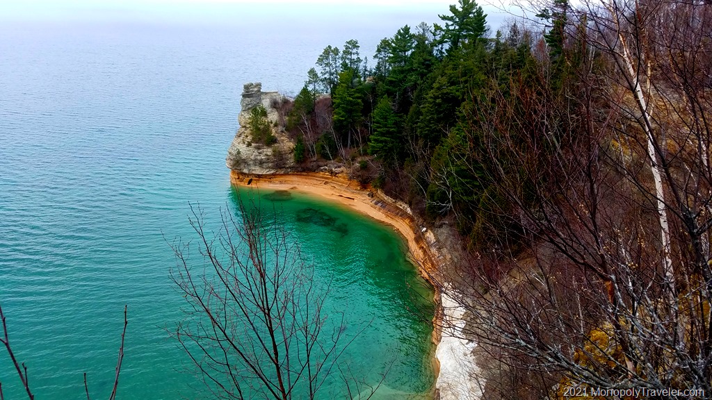
Ready to explore some of the cliffs, we packed back in the car and headed to another area of the park. It was now lunchtime so we made a detour to head into Munising for a little nourishment. Once our hunger was satisfied, it was time to see some of these pictured rocks the park is named after. With only a short time before needing to continue our journey home, we decided on seeing the most popular of these cliffs – Miner’s Castle. There’s a nice overlook here with trails winding through the woods allowing people to see the Miner’s Castle up close. Reaching the first viewing area overlooking Lake Superior and the coastline you could see beautiful turquoise water that should only be in the Caribbean. The view is enhanced by the reddish sandstone rising out of the water and then topped by beige stone above, which can be seen in the top photograph. From here we wandered along the shore to another viewing area allowing people to see the castle close up and study the beige/white coloration along with the interesting formations creating this sculpture. During our time at Miners Castle, we interrupted a wedding party taking pictures. They were very nice and understanding allowing us to step to the platform for a better view of these rocks.

Needing to continue on our journey home, we left the castle viewing spot heading back to the car. Along the way we crossed the North Country National Scenic Trail. What a beautiful location to hike! This is a trail I’ve researched some and thought how fun it would be to backpack on. At least portions of it.
While walking back to the parking lot, fog was blowing over the trees above creating an interesting, if not eerie, landscape. Loaded back into our car I entered directions back home in the GPS, both a little sad our time here was over and looking forward to getting home. But first, Miner’s Beach is on the way and we may be able to see more of this fog drifting into the trees. How about a quick stop here to see a bit more of the landscape and walk on a sandy beach one last time for Spring Break? Entering the beach we could see the fog forming on Lake Superior with the wind blowing into the shoreline. Satisfied with the views from this final beach, we hit the road going west towards the horizon.