Young Bald Eagles

I’ve been fortunate this year to watch bald eagles as they maintained their nest and are currently raising young eaglets. I don’t visit frequently as I prefer to allow them to continue without being disturbed too frequently risking their departure earlier than they should. I’ve only been close enough to see the nest a couple of times.

Stretching their wings

The first was in March before there were any leaves on the trees making it easier to find. They could also see me easily and were not happy about me being in their territory. It was at that time that I learned exactly what bald eagles sound like and have been able to identify their calls since. There have been several times I’ve been in the area and heard their calls telling me they’re still occupying the nest and raising the young without going near the nest. Being able to recognize their calls have directed me to other nests now that I know what I’m listening and looking for.

Being Spotted

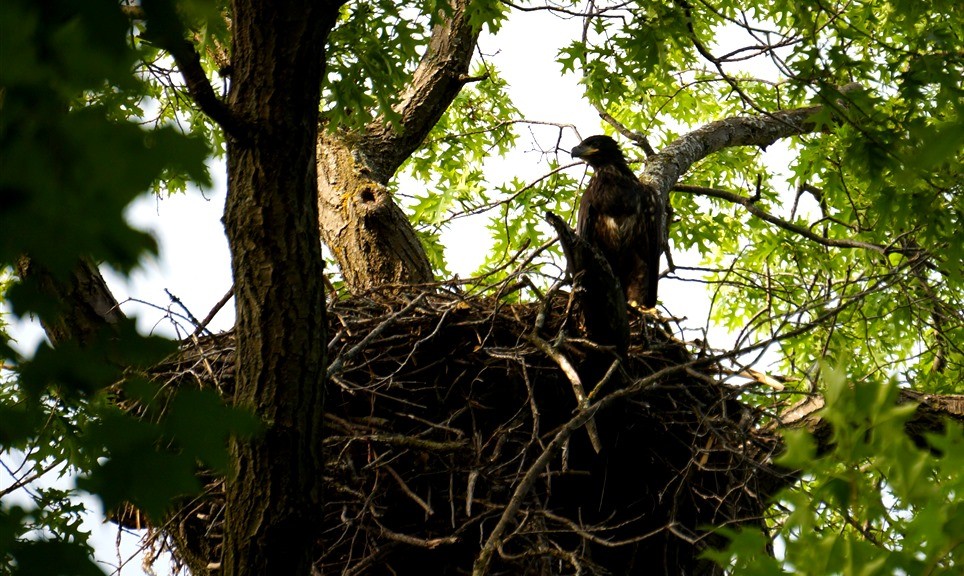
My second visit to their nest was later in the spring after all of the trees grew leaves hiding the nest from most spots on the ground. Fortunately I found an area to observe and photograph the eagles for a short time. During that time the adults fed their eaglets and the young eagles danced around the nest before and after eating.

While photographing I didn’t realize that one of the adults was searching for the sounds my camera was making until it was looking directly at me. Once spotted the eagle began screeching and flew a short distance away while the eaglets hid inside their huge nest built from large sticks.

A little while later the young eagles began peering over the sides at me again and I decided it was time to leave them so they could continue on with life. Soon I expect they will be flying and difficult to find near the nest but it was fun and educational to watch them for a few hours.

Unhappy adult Bald Eagle


Petroglyph

Excited to begin our Spring Break adventures, we landed in Albuquerque, New Mexico on a warm spring like day in mid March headed to Petroglyph National Monument. This National Park is a smaller park in Albuquerque established to preserve the rock drawings created hundreds of years ago. This was our second Monopoly board excursion with much to see and learn.

Walking through Petroglyph National Monuments enjoying the snow capped mountains behind

Petroglyph has a number of short hiking trails which bring you near many of the drawings carved into volcanic rock by people living in this area long, long ago and a modest visitors center to provide more information of this area and its formation. We took in a few of these hikes while enjoying the warmth on this bright, sunny afternoon with mountains lining the horizon. A great day to be here, especially since when I returned a week later it was to snow and ice blanketing many parts of this area.

Studying on of the petroglyphs

Most of the hikes wonder around and through rocks and what must younger people do when approaching rocks? Well they must be climbed of course. Before allowing them to touch a rock we tried to find any petroglyphs so they would risk damage even though these rock drawings have been there for hundreds of years and likely have been climbed over numerous times before.

If there are rocks around, they must be climbed

While hiking we would come upon a petroglyph which was interesting but it seemed like a bunch of kids were let loose in the park with sticks or rocks and told to draw on the rocks. How did we know if the drawings were 5 days old or 500 years? It was hard to know in most cases so we had to just believe these have been there for a long time. We were amazed at how well preserved they were given how long many have been here although I’m very poor at analyzing them to figure out what they may be showing so well preserved or not, I couldn’t really decide what they were portraying. Most of the petroglyphs were simple shapes to depict and animal, bird, or person with some being more intricate to show a particular type of person or event. Seeing these rock drawings in person provided some great historical education to think back on when traveling to different places.

Climbing Around in Shenandoah

After a long day on the road that started in Knoxville, Tennessee, we ade it to Shenandoah National Park in time to view a great sunset. The next day was for exploring the park. Driving along Blue Ridge Parkway we came upon a trailhead and stopped to see where the trail lead. It was Bearfence trail leading to Bearfence Overlook, a nice 1 mile hike to start out on.

Climbing up Bearfence trail

There are two options to hike on Bearfence. First, you can take the Appalachian Trail for most of the way to the overlook and then cut up on Bearfence Trail to arrive at a beautiful mountain view or you can take Bearfence Trail most of the way climbing up and over sharp rocks for a good portion of the mile. Which one would you take? The rock scramble route it is.

The Rock Scramble

The trail starts out on a portion of the Appalachian Trail but quickly begins climbing up into the mountainous rocks of Shenandoah. Some of these areas are fairly steep and go over sharp plates angled up towards the sky. Navigating through the trail requires following blue painted markers on the rocks which are fairly easy to find among the different boulders.

Taking a break

As we neared the top we took a few moments to enjoy the views around us before continuing to the Bearfence overlook. On this beautiful sunny morning we could see several valleys and hills covering miles from these gray colored boulders covered in multiple colors of lichens. The wind was blowing strong enough that we had to be a little careful in our steps otherwise we would be moved off of the trail and in the wrong spot that could result in slipping causing an injury.

Plants growing in the rocks

Something that struck me as interesting was the pockets of water tucked amongst these massive rocks making up the mountain and the different types of plants growing out of the rocks. In a single grouping, such as the one in the photo above, you would have moss, ferns and sedum all protected in a crevice. Moss and ferns generally like moist conditions while sedum tend to thrive in dryer situations which is why these plants growing in the same spot seemed odd to me. Does that indicate the different conditions over a year that combine to create a harsh environment? Wet at times and dry in other times?

Nearing the top

Continuing on the trail, we climbed up and around rocks and boulders as we explored all it had to offer forgetting the workout required to get to the top. It was just fun to experience the Appalachians in Shenandoah National Park in this manner. We were never sure where the end was or if we passed it so we just followed a trail and kept on hiking.

Bearfence Lookout

The end became very obvious because there was no more trail on top of a rock with drop offs on three sides. Once again the views were amazing as we looked out over the neighboring hills separated by meandering valleys and trees all around us typical of these mountains. After a short time we worked our way back to the car, off to explore other areas of this National Park.


Rio Grande

While in Big Bend National Park to hike the Window Trail we traveled to see the Rio Grande which separates the United States and Mexico. It seemed somewhat ridicules to be this close to one of the US borders and not take some time to visit it first hand. From a distance there were mountains on the horizon which somewhat matched my expectations of what this area would look like.

The Rio Grande

For whatever reason, whether from photos or things I’ve read, I expected there to be a canyon kind of like the Grand Canyon with a river running through it and on one side would be the United States and the other Mexico. In this particular area that was not really the case. On one side was a desert, relatively flat, and the other was a tall cliff separated by the Rio Grande.

Looking north to Big Bend National Park and the Chisos Mountains

Making our way to the Santa Elena Canyon Trail we discovered that the river bends and enters a canyon with sheer cliffs on either side. Maybe this is why my expectations were of a canyon with the Rio Grande running through it. Even so, I was surprised by how steep these canyon walls are and how small the river is. At least how small it was while we were there. During times with higher rain amounts I imagine this river to swell considerably. While learning more about the Rio Grande we found out that one of the issues with it being a major border was that the river can change course over time from a rising and falling river which also can change the border between Mexico and the United States.

Rio Grande inside the canyon

Shortly after exploring the Rio Grande I realized that this completes our adventures from one end of the United States to the other. We’ve been to the Canadian/United States border after hiking in Isle Royale National Park, the United States/Mexico border while in Big Bend and the East Coast and West Coast. Also we explored Alaska/Canadian border. The only piece left is Hawaii which will be our final trip in 2018.

image