Category Archives: National Parks

Hot Springs

Hot Springs National Park was a little surprising to me. I know that there are hot springs there and heard a little about bath house row but expected that much of the park consisted of natural areas with hiking trails through it. Usually there are entrances to the park with signs near the boundaries indicating your arrival.

Spring flowers blooming in abundance

In Hot Springs you drive into town and come upon bath house row which includes the visitor’s center and park sign.  As we drove towards this park following our GPS navigation system it announced we had arrived. I looked up and there was bath house row immediately in front of us. Where were the hiking trails? As we continued to explore this National Park we found a scenic drive with overlooks, that we’ve become accustom to, since these bath houses were closed for the day.

Looking out over Hot Springs

During our exploration we discovered a couple of hot springs running out of the ground. It was surprising how hot the water is trickling from these springs as they steam in the cooling evening air. Even though we knew the water was warm we were unprepared for how warm – hot the water is.  It averages 143 degrees Fahrenheit which is warmer than I thought it would be. A nice, unexpected treat as we wondered through the National Park on our first evening in the area.

Two of the hot springs emerging from the ground

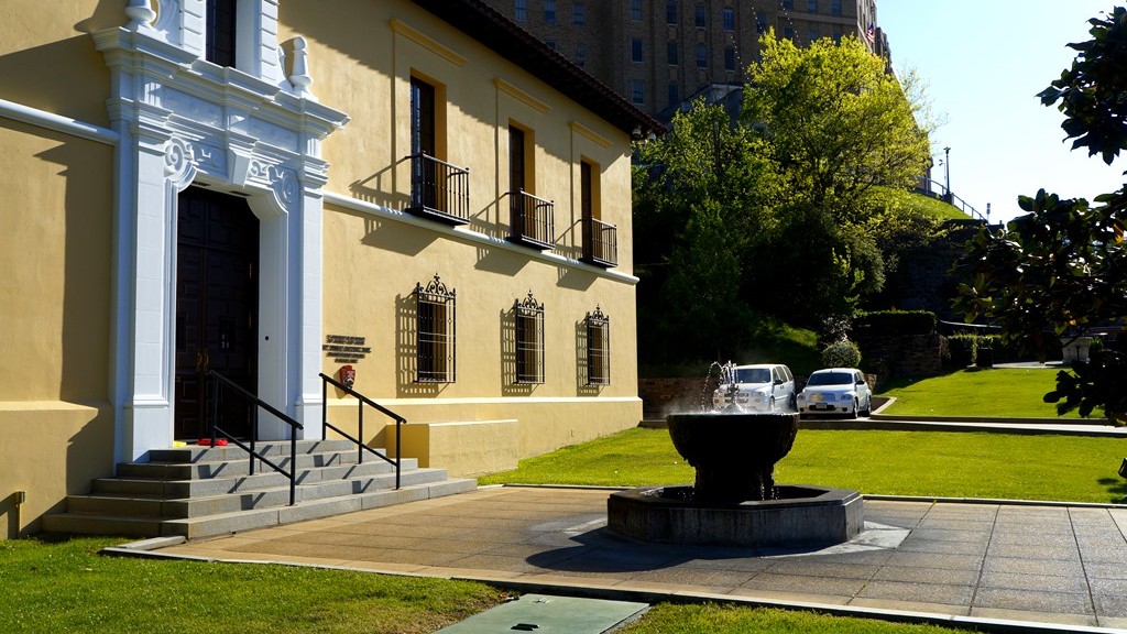
The next morning we returned to bath house row just before they began opening for the day and wandered around looking at all these magnificent buildings built to provide hot, soothing baths before hot baths were commonplace. To be honest, when I first heard of bath house row I imagined more of a brothel type situation but learned that these bath houses where for relaxation and healing which was confirmed by the acknowledgement of the US Park Service maintaining this area. They probably wouldn’t do that if they were in fact brothels. My perception of the bath houses of Hot Springs was changed.

Looking down Bath House Row

Once these buildings began opening we entered the Fordyce Bath House which is now the park visitor’s center and used to explain how bath houses operated and the services they provided. We began by learning about bath house row and some of the history of the bath houses lined up next to each other. Then we moved on to a changing and waiting area for use of the showers and bathtubs.

Waiting and Shower lounge

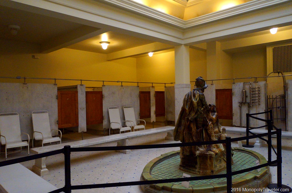
While walking around exploring the Fordyce Bath House we were able to see some of the showers and tubs people would pay to use for the hot water flowing from their faucets to soothe their aching muscles and sore joints. These were the first “hot tubs” and provided the basis for using hot water to relax and recover in.

One of the bath tubs used to soak in the natural warm water

It is interesting to see how many pipes and shut off handles were used in these bath house showers.  Probably the basis for today’s more extravagant showers. It’s difficult for me to imagine what baths and showers would have been like without hot water heaters. Not very pleasant I would guess especially in the winter months.

Hot Springs shower

Other people would opt for a steam bath so they would climb into these steam boxes where they would sit and have steam from these hot springs pumped into the boxes helping to heal sore muscles and joints. Any piece of these hot springs were considered beneficial and having healing properties. Today these types of therapy are in most house holds all thanks to water heaters.

Steam chambers

Once their time in hot showers, warm baths, or steam chambers was complete they would take time to just sit and relax enjoying their reprieve from aches and pains. There were spaces created for doing just that with comfortable seating, soothing music playing, pool tables, fireplaces, or places in the warming sun to sit.  For many people, these life recharging waters would be an all day event. Athletes began to visit these houses to help their recovery speed up because of the healing benefits of Hot Springs.

One of the areas to relax after a hot springs bath or shower

The U. S. National Anthem

Every time I hear the United States National Anthem, there is a deeper meaning after visiting the place it was written – Fort McHenry in Baltimore, Maryland. One of the first things you can see upon nearing the fort is the tall flagpole carrying a huge American flag which author Francis Scott Keys was looking for during the bombing of the fort by British soldiers.

Canons protecting the fort

Once inside the fort, you can see where the canons that defended this fort during the attack were placed. This brings the attack to life imagining soldiers maneuvering cannons and loading them to fire back at British ships in Chesapeake Bay outside of the fort while taking cover as these ships fired back.

Looking out into Chesapeak Bay where the National Anthem was first written

Walking along the top of the fort walls, Chesapeake Bay is clearly visible shining in the bright blue, sunlit sky. After seeing the fort and many of its canons you begin to visualize British ships in the water firing almost causing you to quickly duck back behind the brick walls for protections.

Watching the flag flying in the wind high over Fort McHenry

It’s very humbling to think of this large icon of America, its flag, flying in the wind while soldiers engaged in heavy battle firing at each other through a smoke filled sky created from canon fire. To imagine what this must have looked like to Francis Scott Keys and the impact it had on him during these days. His surprise, joy, and pride to see Fort McHenry and the United States flag continuing to exist in all their glory once the battle ceased. On this Independence Day I have further respect for those who have given much to give us our freedom and continue to defend it yet today!

A huge American flag flying in the courtyard


Petroglyph

Excited to begin our Spring Break adventures, we landed in Albuquerque, New Mexico on a warm spring like day in mid March headed to Petroglyph National Monument. This National Park is a smaller park in Albuquerque established to preserve the rock drawings created hundreds of years ago. This was our second Monopoly board excursion with much to see and learn.

Walking through Petroglyph National Monuments enjoying the snow capped mountains behind

Petroglyph has a number of short hiking trails which bring you near many of the drawings carved into volcanic rock by people living in this area long, long ago and a modest visitors center to provide more information of this area and its formation. We took in a few of these hikes while enjoying the warmth on this bright, sunny afternoon with mountains lining the horizon. A great day to be here, especially since when I returned a week later it was to snow and ice blanketing many parts of this area.

Studying on of the petroglyphs

Most of the hikes wonder around and through rocks and what must younger people do when approaching rocks? Well they must be climbed of course. Before allowing them to touch a rock we tried to find any petroglyphs so they would risk damage even though these rock drawings have been there for hundreds of years and likely have been climbed over numerous times before.

If there are rocks around, they must be climbed

While hiking we would come upon a petroglyph which was interesting but it seemed like a bunch of kids were let loose in the park with sticks or rocks and told to draw on the rocks. How did we know if the drawings were 5 days old or 500 years? It was hard to know in most cases so we had to just believe these have been there for a long time. We were amazed at how well preserved they were given how long many have been here although I’m very poor at analyzing them to figure out what they may be showing so well preserved or not, I couldn’t really decide what they were portraying. Most of the petroglyphs were simple shapes to depict and animal, bird, or person with some being more intricate to show a particular type of person or event. Seeing these rock drawings in person provided some great historical education to think back on when traveling to different places.

Climbing Around in Shenandoah

After a long day on the road that started in Knoxville, Tennessee, we ade it to Shenandoah National Park in time to view a great sunset. The next day was for exploring the park. Driving along Blue Ridge Parkway we came upon a trailhead and stopped to see where the trail lead. It was Bearfence trail leading to Bearfence Overlook, a nice 1 mile hike to start out on.

Climbing up Bearfence trail

There are two options to hike on Bearfence. First, you can take the Appalachian Trail for most of the way to the overlook and then cut up on Bearfence Trail to arrive at a beautiful mountain view or you can take Bearfence Trail most of the way climbing up and over sharp rocks for a good portion of the mile. Which one would you take? The rock scramble route it is.

The Rock Scramble

The trail starts out on a portion of the Appalachian Trail but quickly begins climbing up into the mountainous rocks of Shenandoah. Some of these areas are fairly steep and go over sharp plates angled up towards the sky. Navigating through the trail requires following blue painted markers on the rocks which are fairly easy to find among the different boulders.

Taking a break

As we neared the top we took a few moments to enjoy the views around us before continuing to the Bearfence overlook. On this beautiful sunny morning we could see several valleys and hills covering miles from these gray colored boulders covered in multiple colors of lichens. The wind was blowing strong enough that we had to be a little careful in our steps otherwise we would be moved off of the trail and in the wrong spot that could result in slipping causing an injury.

Plants growing in the rocks

Something that struck me as interesting was the pockets of water tucked amongst these massive rocks making up the mountain and the different types of plants growing out of the rocks. In a single grouping, such as the one in the photo above, you would have moss, ferns and sedum all protected in a crevice. Moss and ferns generally like moist conditions while sedum tend to thrive in dryer situations which is why these plants growing in the same spot seemed odd to me. Does that indicate the different conditions over a year that combine to create a harsh environment? Wet at times and dry in other times?

Nearing the top

Continuing on the trail, we climbed up and around rocks and boulders as we explored all it had to offer forgetting the workout required to get to the top. It was just fun to experience the Appalachians in Shenandoah National Park in this manner. We were never sure where the end was or if we passed it so we just followed a trail and kept on hiking.

Bearfence Lookout

The end became very obvious because there was no more trail on top of a rock with drop offs on three sides. Once again the views were amazing as we looked out over the neighboring hills separated by meandering valleys and trees all around us typical of these mountains. After a short time we worked our way back to the car, off to explore other areas of this National Park.


Rio Grande

While in Big Bend National Park to hike the Window Trail we traveled to see the Rio Grande which separates the United States and Mexico. It seemed somewhat ridicules to be this close to one of the US borders and not take some time to visit it first hand. From a distance there were mountains on the horizon which somewhat matched my expectations of what this area would look like.

The Rio Grande

For whatever reason, whether from photos or things I’ve read, I expected there to be a canyon kind of like the Grand Canyon with a river running through it and on one side would be the United States and the other Mexico. In this particular area that was not really the case. On one side was a desert, relatively flat, and the other was a tall cliff separated by the Rio Grande.

Looking north to Big Bend National Park and the Chisos Mountains

Making our way to the Santa Elena Canyon Trail we discovered that the river bends and enters a canyon with sheer cliffs on either side. Maybe this is why my expectations were of a canyon with the Rio Grande running through it. Even so, I was surprised by how steep these canyon walls are and how small the river is. At least how small it was while we were there. During times with higher rain amounts I imagine this river to swell considerably. While learning more about the Rio Grande we found out that one of the issues with it being a major border was that the river can change course over time from a rising and falling river which also can change the border between Mexico and the United States.

Rio Grande inside the canyon

Shortly after exploring the Rio Grande I realized that this completes our adventures from one end of the United States to the other. We’ve been to the Canadian/United States border after hiking in Isle Royale National Park, the United States/Mexico border while in Big Bend and the East Coast and West Coast. Also we explored Alaska/Canadian border. The only piece left is Hawaii which will be our final trip in 2018.

image


Playing in Padre

After several days in Big Bend National Park we sped across Texas going from the deserts of Southwestern Texas to the Gulf Coast for our next National Parks Monopoly board destination of Padre Island National Seashore. Fortunately the big spring break crowds were here a couple of weeks earlier leaving quieter beaches for us to explore. There was a brief debate about which is better, rocks to climb or the ocean beaches. It was a short debate with the ocean winning.

A quick walk in the ocean as the sun set behind us

Padre Island is a narrow, long island running along the southeastern portion of Texas providing miles and miles of beautiful sandy beaches to get lost in all day long. Padre Island National Seashore actually has 60 miles of beach that can be driven on if you have the right vehicle. Since we had a regular car we were unable to explore past the first 5 miles of beach which has sand packed hard enough for almost any vehicle to pass over. Beyond this first 5 miles the sand is more loosely packed making it possible to sink in and become stuck which is why 4 wheel drive vehicles are recommended.

Sandy dunes shaped by ocean breezes

In addition to enjoying listening to the waves continually crash against the shore and taking a leisurely stroll through the waves, there is plenty of wildlife to capture your interest for awhile. Some of them required your attention while walking by the water as there could be consequences if you get to close. One of those was the Portuguese Man-o-war’s floating into shore on an occasional wave and landing in the sand until another wave is able to bring it back out to sea. They can sting you even when laying along the beach so watching your step is important. Many of these stranded on the beach were varying shades of blue making a beautiful contrast to the beach.

Portugese Man O War stranded on the beach

Another creature to watch out for near the edge of the water are crabs. Mostly we came across blue legged crabs and if walking close enough, they may pinch you in an attempt to scurry away without being crushed. They were great fun to watch, as long as you saw them before you were too close, while they crawled on the sand scavenging for food. These ranged from almost colorless to an intense blue on their legs giving them their name.

Blue legged crabs near the edge of the water

A very common sighting on the beach are numerous birds scattered everywhere . There are a number of different types from gulls to herons all searching for the next snack in and out of the waves. A great source of entertainment while taking in the rejuvenating rays from the sun on a beautiful Texas afternoon. We were trying to determine what they were eating just inside the wave zone as they appeared to be plentiful. After watching for a short time and exploring the beach we realized what the meals were.

Birds combing the beach in search of their next snack

Small clams of every shade lay just under the sand surface and would quickly emerge as a wave would approach revealing themselves to birds. As we watched and dug more these little sand dwellers were everywhere. When walking along the water’s edge you were walking on thousands of them, usually without ever knowing as they lye just below the surface waiting for the right wave to arrive. It was amazing and a little unnerving to know you were walking on hundreds of them with each step.

Clams rising out of the sand getting ready for the incoming wave

A quick brush of the sand and you would see them burrow to the surface all around you. There were white ones and blue ones, yellow clams and purple clams, some with strips while others were solid in color. Another great source of entertainment while relaxing on the beach. I don’t know what type of wave they were looking for but once the right wave was nearing the beach, thousands of these little clams would appear above the sand as if by magic standing straight up. Once the wave passed they would tip over laying on the beach and after another wave, disappear back into the sand making you wonder if you really saw this spectacle or imagined it.

Thousands of clams lying just under the surface of the sand

All in a days fun along the Padre Island seashore before retreating to find your next meal.

A Blue Heron taking in the sun rising over the ocean


Canyon De Chelly

Canyon De Chelly was a National Park we haven’t heard of before and a brief search before visiting basically informed us that it is a canyon in Arizona. It may not be largely publicized because of that other little canyon in Arizona called The Grand Canyon. Canyon de Chelly is a beautiful park where the floor is still in use today by the Navajo for farming as this park is part of the Navajo Indian Reservation.

Canyon De Chelly

We enjoyed exploring this National Park as it is a beautiful place amongst the Colorado Plateau with the uniquely carved out canyons and amazing rock formations all made out of red tinted stone. There are numerous overlooks surrounding this park each providing a great view of canyon and surrounding area. The longer you look at the rocks you begin to see more and more details such as stone carved by the natural elements, rock stacked together creating layers upon layers highlighted by different colors, and areas where the rocks have fallen away from the cliffs created caves.

Spider Rock

There is one designated trail that allows you to hike into the canyon without trespassing on Navajo lands at the bottom so we decided to take advantage of that opportunity. There are tours available led by Navajo guides as they are the only ones allowed to bring people down into the canyon outside of this trail.

Hiking into the canyon

The trail takes about 15 – 20 minutes as you wind back and forth among the stones descending about 600 feet to the bottom. Along this hiking trail there are tunnels and caves providing some great locations for people to escape the elements. They also made great additions to the scenery throughout the canyon. Once at the bottom you get a very different perspective of this stone maze. There’s a better understanding of how tall these cliffs are and how large this canyon is. Plant diversity becomes apparent as many areas are dry providing an environment for cactus to grow while near the river running along the bottom gives moisture for trees and other plants.

Some of the caves carved into the canyon walls

At the end of the trail you can explore one of the areas cliff dwellers inhabited at one time. The structures are kept behind a fence in order to preserve them but they are still interesting to see and makes it a little easier to imagine what it must have been like living in this canyon before the conveniences of horses and vehicles. What was it like to create multiple level buildings climbing up cliffs into large caves? These cliff dwellings were an unexpected surprise for us as we explored Canyon De Chelly National Monument.

Cliff dwellings up close


Window Trail

Entering Big Bend National Park

Our Monopoly board brought us to explore Window Trail which lies inside of Big Bend National Park. This is a moderately difficult trail which covers 3.6 miles in total and covers some beautiful scenery along the way. We were fortunate to be there during the spring when many plants were beginning to bloom and the temperatures were ideal for a hike in the desert. Not to cold and not to warm.

Walking through the desert

Along this trail we enjoyed a number of great sights including Yucca’s and cactus in bloom, a couple of white tail deer, colorful birds, and a friendly road runner. This trail follows the bottom of a canyon most of the way where water drains during heavier rainfalls.

Taking a quick break on the trail

About halfway to the end of the trail we decided it was time to explore a place to take a few minutes to relax and take in the great desert mountain scenery. What’s the first thing kids want to do when stopping near rocks? Well climb them of course and this we did as some of the nicest seats were higher up. This is not recommended by the park although we were definitely not the first ones to do this as I found an orange peel in one of the crevices left by a previous climber.

Window Trail through the canyons

Once entering the canyon portion of the hike there were stairs built to make the trail easier to traverse as during other times of the year there can be water flowing through here which is, of course, the way this canyon was created.

The window where the trail ends

At a couple of points along the way we wondered if we were at the end of the trail. I can say definitively now that the end is very obvious because of seeing the window it was named after and it drops off to the desert floor very abruptly. I’m not sure a person would survive a drop from the window.

Rocks smoothed by years of water and debris sanding them down

As you get close to the window the rocks become extremely slippery due to the running water carrying debris which has sanded down the rocks giving them a polished appearance and feel. It was interesting, especially in this dry season, to see how high the water can get in this canyon and how fast it must rush through to wear down the stone underneath.

The end of the trail with a steep drop to the desert floor

Carefully climbing near the end there is just a narrow slot with a large drop-off which is all very slippery requiring some care to get to. It would be interesting to see this area from the other side after a heavy rain. There must be an interesting waterfall for a short time.

A road runner encounter on the trail

During our trek back we encountered this road runner that didn’t seem to care we were there as it walked right next to us on the trail. Other hikers behind us had the same experience. This particular bird must be use to hikers on this trail and understand prey can be found scurrying as hikers pass by making them easier to find. It gave us the opportunity to all see a road runner finally as each time before the birds would be gone before everyone could see them running across roads in front of the car.

Meandering Through the Smoky Mountains on a Horse

Exploring a National Park by driving and hiking through it is the most common, riding a horse was something different for us and what better place to do that than Great Smoky Mountains National Park? There are a couple of horse stables in this park. The one we chose was Cades Cove Riding Stables because that was the one closest to where we wanted to explore that day.

The Rhododendrons were just starting to bloom

Our ride lasted for about an 45 minutes through beautiful forests of the Smoky Mountains so it was long enough to enjoy it but not too long where those of us not use to horses would get sore. The day began cloud covered with the threat of rain but we managed to stay dry and see peaks of sun as the ride continued making for a great summer morning while taking in these surroundings. Several of the Rhododendrons were just beginning to bloom along the trail providing for an even prettier landscape to ride through.

Beautiful scenery on a beautiful summer morning in the Smoky Mountains

The trail leader was very knowledgeable about the horses and trails and took care of any potential issues with the horses quickly. Some horses just don’t perform as well next to certain other horses so sometimes it’s best to keep them separated in a group. Once in awhile a horse wants to go at a different pace than the rest of the group and needs to be put back in their spot to follow the group for the best and safest ride for all. If your in Great Smoky Mountain National Park and are interested in spending time on horses, I definitely recommend Cades Cove Stables. And NO, I was not compensated to say that.

Riding through one of the numerous streams

Fireflies in the Smoky Mountains

While exploring Great Smoky Mountain National Park we came across a brochure explaining the synchronous fireflies. Fireflies are visible  in many areas and we’ve enjoyed and evening or two watching these interesting little insects near our home. I’ve even taken some time to try and photograph their nighttime dances with some success. It was decided that a trip to Elkmont, which is the best location for viewing this nightly light show in June, that night would be an enjoyable way to end a great day in the Smokies.

A Dobson Fly also waiting to see the light show.

According to the brochure, the peak days were already behind us but that there were great light shows for several weeks still to be seen. As we arrived in the Elkmont area our first challenge was to find a spot to park which proved more difficult than expected as we were there a couple of hours before nightfall. Apparently we weren’t the only ones wanted to witness these synchronous fireflies. Eventually we followed others and parked alongside the road and walked back to the viewing area which was being descended on by hundreds of other people. This must be a good show if there are this many people here this early in the evening.

Little River in Elkmont

As darkness began to fall over the area we wondered into the forest next to Little River and found what appeared to be a nice relaxing spot to lose ourselves in the increasing darkness along with others hoping to witness a firefly spectacle. While waiting for these insects to begin their show we explored the river’s edge until a flash caught our attention back in the woods. And then another, and another. The show was beginning! As the minutes went by there was some firefly flashing but nothing more spectacular than we would see near home. After about 20 minutes we decided it was time to retire for the evening as it was a long and eventful day leaving us ready for our pillows.

A single firefly lighting up the night

On our way out of the forest we stopped to talk with another couple who lived in the area. During the conversation they explained that the show had not really started yet and we should stay awhile longer. Soon after there were golden streams of light blinking all over. It was beautiful and exciting to watch. They were all over the place showing off their tricks of flight and color. Now it makes sense what all the publicity was about. We couldn’t imaging what the show would be like during the peak season. Now this was about as perfect as it could be to end a day full of adventures.

The show is getting better

And better

This is definitely worth seeing