Category Archives: Adventure

Merganser Feast

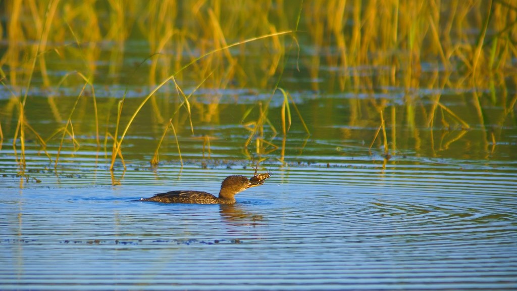
Before the sun had risen above the horizon at Lake Itasca in Northern Minnesota I ventured to a dock hoping for a foggy morning scene. There was some fog hanging onto the lake as sunlight began casting shadows from the pine and maple covered shoreline but not the epic foggy morning dreamt about the night before. Everything was so still waking up from a cool summer night. So peaceful! The type of morning I have come to cherish. As I was soaking in this serene landscape movement caught my attention. Ducks swimming slowly through vegetation nearby. With camera already resting on it’s three legged perch I stared into these grasses watching as ducks disappeared under the water’s surface and returned again all without making a sound. Only the ripples giving them away. Zooming in on one of these busy birds I noticed something in it’s mouth appearing to be a crayfish.

Early morning on Lake Itasca

Watching intently through my cameras eye the outline confirmed my suspicions. It was indeed a crayfish caught in the beak of a merganser. This hard shelled creature appeared much to large to be swallowed by the little mouth of this bird so I continued to watch, snapping a few pictures along the way, as it wrestled to get it’s next meal ready to eat. As if it were dancing, this duck would swing it’s head from side to side opening its clamping beak attempting to shift the crayfish in another direction before dipping it underwater as if rinsing it off in preparation to eat it. The crayfish dance would be repeated for several minutes until finally satisfied this meal was ready to be consumed. All the while the crayfish appeared to be in a state of uncertainty of what was going on. Only moments before it was the predator eyeing up the next meal.

Another crayfish caught by a Merganser

Once this early morning meal had reached the stomach of this merganser it was back to hunting. A water bird of this size appeared unable to handle more than one of these bottom dwelling creatures and yet continued searching for more. Watching this happen several more times I began wondering just how many crayfish can a little duck eat before becoming too lethargic and tempting a nearby perched eagle into a possible easy meal. Finally the mornings feast seemed to come to an end and preening was the next event on this cool, sunny mornings calendar. A few dunks in the water while flapping its wings before drying off in the warming sunlight in preparation of checking that all of this little ducks feathers were perfectly in place removing those that were not. Returning to the soundless swimming in and out of grassing camouflaging this brown aquatic bird from sight before once again losing it under the waters surface.

Drying out after a morning full of diving for crayfish

Scanning over the nearby waters surface this merganser re-appeared once again holding another crayfish in it’s tiny beak. The dance continued, although as if perfected, lasted a much shorter time before another crayfish was swallowed whole into the small mouth of a motivated predator. By this time more people were stirring causing these little ducks to retreat further into the weeds protecting them from the large two legged animals wandering along the shoreline. It was time to store my camera and tripod back into its protective sack relinquishing my place on this dock for others to begin launching their water crafts for a summer day out on the water.

Another unlucky crayfish

How About One More?

We were all really sad to have our Monopoly travels come to an end in Hawaii and didn’t really want our National Park adventures to come to an end but there we were visiting an active volcano which was placed at the end of our trips as an incredible end in our family journey. Fortunately I found a loophole (excuse to visit another park) giving us another opportunity to explore a different National Park as a family. The Monopoly board has three ‘chance’ spots on it and three ‘community chest’ spots which we figured where there for us to pick out six of our own places to go. After a little discussion it was decided the ‘chance’ places would represent three different caves we’ve explored – Wind Cave, Jewel Cave, and Mammoth Cave. For the ‘community chest’ locations it was thought the three national parks in Minnesota would make sense which includes Grand Portage National Monument, Pipestone National Monument, and Voyageurs National Park. All of these have provided adventures for us on previous trips with the exception of Voyageurs National Park so that is where we decided to go this summer as an unofficial ending for our Monopoly adventures.

Lost in the beautiful sights at the Minnesota-Canada border

While there we experienced a range of temperatures with days of 90+ degrees Fahrenheit which is unusual for extreme Northern Minnesota and days in the upper 60’s with nighttime lows reaching into the 40’s. Since we were camping there were times the heat was a little uncomfortable and so were the coolest of nights causing us to shiver while trying to sleep. The beautiful landscape made the time at the most northern portion of Minnesota very enjoyable. Much of Voyageurs is surrounded by water so to really take in this park some of the time should be spent on the water fishing, canoeing, or just exploring. We planned on going canoeing one afternoon and taking a boat excursion another day. Unfortunately we were unable to get on one of the boat tours and on the day of our planned canoe trip the wind was too strong causing that to be canceled. So there we were without an opportunity to travel over these same waters voyageurs would transport their furs over a long time ago. This didn’t stop us entirely from enjoying the water. On one of the hot afternoons we found a place to venture out wading through the nice, cool lake water to find some relief from the heat.

Camping in the northwoods

We intentionally timed this adventure to coincide with the Perseid Meteor shower peaking throwing a meteor per minute across the dark sky. Where better to watch this astrological event than a dark sky location like Voyageurs National Park? Fortunately our first night stargazing was mostly clear allowing us to watch as these amazing meteors streaking across the sky. Previous to this Canadian fires provided enough smoke creating a thin blanket over the sky preventing many of the meteors to be seen. We were not alone in our quest to see these fireballs blazing their way through the night sky as every park ranger we talked with also took time to look up and find a meteor or two during the night. This was certainly one of the highlights of our time in this great National Park. In the photo below you can barely see a meteor lighting up the sky in the middle near the top. It’s quite faint so you really need to look closely. Also in this picture is a portion of the Milky Way which can identified with the real bright spots combined with real dark areas in the left portion of this photograph. It almost look like the branches from a pine tree on the left side are pointing to the Milky Way.

Watching the Perseids

During the day we found a few trails to hike allowing us to take in this serene landscape as it uses the final weeks of summer to prepare once again to enter dormancy to survive the harsh winter conditions not far away in this part of Minnesota. No National Park adventure would be complete without a junior ranger badge so of course one of the first priorities was to get to the nearest visitor’s center and pick up a junior ranger packet. While traveling to different areas of the park we would work on these books eventually completing enough activities to get sworn in and receive badges signifying junior ranger status. Even though our children are older now they can still become junior rangers and usually encouraged to do so by actual Park Rangers.

Another Junior Ranger badge

Probably the weirdest part of exploring this national park was that we were using our own vehicle. Usually we rent a car so that in itself has become part of each adventure. Upon picking up the car there’s a competition to figure out what color it’s going to be along with what state it will be registered in but we didn’t get to do that this time. There was one other time we traveled in our own car and that was while exploring Badlands National Park and Rocky Mountain National Park on our first set of adventures. There was definitely a higher level of comfort doing it this way though because there was no airplane ride which restricted the amount of things we could bring. As our time here dwindled there was once again a feeling of sadness because now we really were on our final national park adventure on the Monopoly Board. There are many more national parks I would like to visit but I’m not sure if we’ll be able to do so as a family in the future so for now our Monopoly Travels which began nine years ago come to a close.

_DSC4659

Under the Surface of Lost Lake

On a recent trip to Lost Lake in the Chequamegon-Nicolet National Forest I read that the water clarity was pretty good so I brought my mask, snorkel. and of course the GoPro to explore the lake under the surface. I’ve never snorkeled in fresh water before so this would be a new experience. In salt water it’s pretty easy to stay afloat due to the high density of that water but fresh water I tend to sink rather easily so was nervous to try snorkeling in deeper water. Lost Lake seemed like a good spot to try as there is a lot of shallower places to swim allowing me to touch the bottom if needed.

G0080117_thumb16

My first adventure into the water brought several interesting observations for me. First, the water was a little cool but didn’t take any more than a few seconds to get use to which was nice. Next, the water clarity wasn’t quite as good as I was hoping for and finally, snorkeling in fresh water wasn’t much different than in salt water as far as being able to maintain my ability to float. I wished I had brought my fins once this was discovered because it was challenging to swim while holding a camera. Fins would make it easier to move forward while using the GoPro to record these beautiful fish.

G0150190_thumb5

I found it easier to move around by using my feet on the ground but that brought up a lot of the decaying organic debris into the water making the clarity even less. Some of the surrounding fish seemed to be happy with me doing that as I’m sure I was stirring up food with the debris. Once being able to move around a little easier I was able to focus more on the different fish, their behaviors, and the underwater landscape which was really interesting. There are pumpkinseed pan fish, perch, small mouth bass, and trout listed to be in Lost Lake. I didn’t see any trout but found the others lurking in weeds.

G0130165_thumb8

The landscape underneath the surface proved to be quite interesting with a combination of living and dead vegetation. Scanning through the weeds at different points there would be fish or two swimming in between them but if I stayed there for a minute or so there would soon be a large school surrounding me. I began to think there would be nightmares later that night of fish attaching from every direction. Fortunately that did not happen! At one point I just stayed in a single spot and turned completely around only to find fish in every direction staring at me. It was kind of cool and a little creepy at the same time.

G0180222_thumb12

Every so often I would come across a bare spot in the floor of the lake. As I watched some of these areas a larger pumpkinseed would return and begin to flare its gills and fins at me in defense of this spot it had previously cleaned off as a nest. I would move towards it and scare this fish away only to have it return a short time later. This wasn’t something I would do repeatedly as I didn’t want it to abandon the nest but found this behavior interesting as I was many times larger than the fish. After swimming among the fishes for awhile I returned to the shore to dry off eagerly wanted to go fishing. It almost seemed like cheating a little because I had found certain areas for certain fish so knew where to cast. That didn’t mean I necessarily caught them even though I had a good idea where they were. Another freshwater snorkeling adventure is definitely on my agenda when I get a chance.

G0170212_thumb6

A Butterfly Day

For the first time since the end of April I actually got out with the camera to see the sun rise and got to enjoy a nice morning while watching some wildlife. Much of the morning was spent watching green and blue herons but there was an hour or so of exploring trails I’ve not been on yet. While hiking these trails I kept coming across butterflies, most of which I haven’t seen before so the hike became even more interesting. The odd thing to me was that most of them were on the ground. They must have been searching for water as they were on wet areas on the ground. The butterfly above is a Hackberry Emperor. Thanks to Minnesota Seasons I was able to identify all of those I saw on this trip.

_DSC3614_thumb4

The first actual butterfly I came across was an Eastern Tiger Swallowtail which I have seen a couple of times before but this one seemed much larger than those I’ve watched previously. Seeing it before did not make it any less fun to watch as it fluttered around landing often on a moist area of the trail. Butterflies are not always the easiest to photograph as their flight is unpredictable and you never know where they’re going to land unless there is a consistent food source they’re taking in. When you get to close they take off making a close up very challenging.

_DSC3661_thumb4

If they’re actively pursuing nectar from flowers you can usually get closer to them or set up the camera on a certain area and wait for them to sip nectar from that area for a great close up. As I walked along the trail I came across culvers root flowers which appeared to attract many bees and a butterfly or two such as this western tailed blue butterfly. Part of the name comes from the blue coloring on the inside of their wings which I didn’t see on this one because it didn’t fly or open its wings while watching it. I enjoyed watching it for a few minutes as it climbed all over the flowers.

_DSC3668_thumb10

Often times I’d be walking along and all of a sudden something would move or fly away not always able to figure out what it was. The northern pearly eye above was one of those but fortunately it landed fairly close allowing me to snap a few pictures of it before both of us moved on. The patterns in the wings amazed me as is often the case with butterflies.

_DSC3693_thumb15

During my short hike the butterfly that was the most colorful and different to me was this red spotted purple butterfly you can see here. First of all being a dark bodied insect really set it apart from the surroundings along with the red, blue, and white spots covering parts of the wings. Secondly it had red spots on the outside of its wings which came out beautifully in the sunlight.

Early on in my hike I was looking at the area landscape when I happened to look down and see an interesting caterpillar crawling around on a spent thistle bloom which seemed fitting as they both have a lot of spikes on them. Researching this one came up with a spiny elm caterpillar which becomes a mourning cloak butterfly later in its life. I’ll have to keep an eye out for those as the summer continues. I don’t remember seeing this many different types of butterflies at one time in one place. It certainly made for a more enjoyable hike.

20180728_093250_thumb6

A Snowmobiling Adventure

Last winter I had so much fun snowmobiling in Northern Wisconsin that I couldn’t wait to do it again so this year the plan was to go earlier almost guaranteeing enough cold and snow to fly across the wintery landscape. As luck would have it the upper Midwest has been relatively warm with precipitation falling as rain instead of snow once again bringing questions of trail quality and snow cover. As the planned day arrived a fresh coat of snow fell bringing many of the trails into great condition for snowmobiling. Let the fun begin!

Getting ready to hit the trails

After a brief check of the snowmobile it was time to hit the trails for a day of adventure through the forests of the North. Thankfully it was a warm winter day under a bright blue sky dulled only by a few wispy, white clouds making for perfect weather to fly on top of the snow covered Earth. As the day progressed miles kept flying by bringing different beautiful landscapes around the next corner.  Portions of the trail glide through dense forests while others are wide open fields with the occasional lake added in to keep the picture ahead changing.

Cruising along on the snowmobile trails

As sunset approached the mileage was reading almost 150 miles clocked during the daylight hours. It was definitely fun amassing those miles through every turn and hill set before us including one that was a little sharper than expected causing a sled to cruise through the corner almost flipping over and running over a few small trees before stopping to allow damage assessment. Fortunately there was none except maybe to a little tree or two which had to be removed before the snowmobile would move under its own power once again.

Taking a few moments to watch the sun set

With the sun now down below the horizon it was off towards our final destination of the day ending at a hotel for a few hours of rest before returning the snowmobiles for the weekend. As the trees flew by the sky continued to amaze with beautiful colors changing from yellows and oranges to reds and pinks distracting from the trail in front.  Fighting through that distraction came yet another one with a full moon rising above the horizon bringing with it a reminder that there was suppose to be a partial lunar eclipse but probably not visible at this Northern Wisconsin location. As daylight turned to darkness this partial eclipse shown across the face of the moon continuing the challenge of focusing on the trail ahead.

Watching a full moon rise partially eclipsed

A quick stop to refuel and off again into the darkness of trees reaching over snow covered trails meandering up and down and side to side until my snowmobile continually slowed down even though the throttle was pushed until it stopped and a small pop came from under the hood. Now what do we do here with nothing but trees as far as we could see. After a half hour of trying to get it restarted without success we decided our current adventure was complete and unknowingly a new one was about to begin.

Thankfully our second snowmobile was a two person sled so we moved the dead snowmobile off of the trail and headed for the nearest town to hopefully secure a place to stay and figure out what to do with the broken one. As the night progressed we learned how to disable the drive on snowmobiles and how to tow them all thanks to Youtuber’s. Grabbing a tow rope we headed back to the disabled snowmobile, disengaged it’s drive belt and towed it back to the rental place over several hours in complete darkness with only the flashlight of our phones to see what we were doing as the moon was now covered by a layer of clouds. Once completed we fell, exhausted into our beds for the night ending this Northern Wisconsin adventure.

Climbing Longs–Continue On or Not?

While taking in the views sitting in the Keyhole, Lysa and I discussed the next portion. Are we up for the next portion of this hike, which becomes a climb, and is considered more difficult than what we just completed. Our initial decision was to sit and enjoy our surroundings and return to the trailhead while the weather was in our favor as storms were predicted for the entire afternoon and clouds were beginning to form. You can see in the above picture of the next portion of our hike. There is a group following the trail towards a valley called the trough. Actually the trail looks fun except for one issue – being able to breath adequately at 13,000 feet. Going beyond the Keyhole the hike becomes increasingly more dangerous as a wrong step on parts of the trail can lead to serious injury and even death as has happened here before.

Sitting and enjoying the awesome surroundings while watching others maneuvering the trail was nice but a feeling kept burrowing deeper inside us. What’s it like on this trail and what’s around the corner that we can’t see? Well there really is only one way to find out! On went the packs as we moved to boulders making up the trail which is marked by red and yellow bulls eyes. The morning sun was warming us at the Keyhole but as we began this portion it was in the shadows with colder temperatures. Thankfully we had gloves as the boulders are quite cold up here. The trail wasn’t too difficult as long as you take your time and watch your step while grabbing boulders to maintain balance and support among this unforgiving granite.

Making our way to the Trough in the background

Time flew by as we slowly made our way up and over numerous rocks towards the valley called the Trough. There are a few challenging boulders to climb over but for the most part it was a nice climb/hike. Reaching the trough fatigue was beginning to set in.  This is concerning because it can lead to poor decision making in a place intolerable to it. Even though we took a few breaks along the way we needed to stop for a longer period of time to regain our oxygen levels and leg strength before the next section which requires continually climbing up.

Clouds continued to build around the mountains causing us to try and push towards the top so we began climbing the Trough as quickly as possible. About a third of the way up we began to get light headed and dizzy at times along with trembling legs. At this point we knew we had to slow down and take more breaks in order to get enough oxygen to continue our climb. After this point we would climb about 10 or 15 feet up and take a short break. That seemed to help maintain our strength but slowed down our climb. While we were climbing up there were others working their way down sliding from time to time making us realize up may actually be safer than coming back down. Occasionally a rock would come flying down towards us from other hikers above requiring us to take cover from time to time until the rock passed without incident. Eventually we picked our way through the rocks getting close to the top of the Trough reaching, what at first glance, was an impassible boulder. Taking some time to study our options we chose a path and nervously worked our way up and over this boulder and arrived what felt like on top of the world. There’s a geological marker here stating that we had made it to 13, 749 feet. Only 500 feet left to the top of Longs.

Climbing the Trough

We sat on a narrow strip of granite taking in our surroundings and resting after this energy draining climb up the Trough in preparation for the next section. Again the discussion arose of continuing towards the summit or not. After a few minutes we came to the conclusion it was time to call it a day and turn around. There were multiple reasons for this. First, clouds were continuing to get darker and there were obvious rain showers in the distance working towards us. Next, we had someone picking us up from the trailhead at a designated time and looking at the current time we were already going to be pushing that time. Finally we were very fatigued and still needed to climb down these difficult sections safely. I estimated we would need another 2 hours in order to make it to the summit and begin our descent which I was not interested in doing in thunderstorms with wet, slippery rock. Especially with my daughter.

The view from the top of the Trough

After taking some additional time enjoying the view, eating and drinking to replenish, and resting to re-gain strength, and talk with other hikers about the situation we began the climb down scrambling around this almost impossible boulder while others tried to figure out their way around it climbing up. With their assistance we made it down safely over this boulder and continued down the Trough making our way to the Keyhole once again. It felt good to be back to this point safely before any rain started to fall. Taking the last few minutes at this altitude we surveyed the area as it’s so incredible knowing we will not likely be back here again in our lifetime.

Taking in the views

Shortly we made our way down to the Boulder Field campground feeling good about what we accomplished and that it’s all down hill on relatively easy trails from here just as thunder began rumbling off in the distance. Better get moving in an attempt to reach the tree line before storms reach us. We didn’t make it far before thunder began to boom overhead bringing with it a rain/snow mix which we hiked in for the next couple of hours. Fortunately there wasn’t visible lightning striking the mountains allowing us to continue our hike instead of seeking out a depression along the trail to take cover in. Yes, the decision to forgo reaching the summit now seemed like a good call as we would have been caught somewhere above the keyhole on wet boulders or possibly snow as the mountain peaks around us were turning white making the hike even more dangerous and time consuming. The rain passed as we reached the tree line with only a few more miles to go before meeting our ride and the end of this adventure filled and tiring day.

Approaching rain/snow and storms

The return brought us down over 6 miles almost without stopping in an attempt to reach safety with storms expected much of the afternoon and then to reach the car. Because of this our legs became increasingly more sore with each step down we had to take. If we would have taken a few breaks to rest we would have been in good shape having accomplished an amazing hike.


Scott’s Bluff

Sounds like a high stakes card game doesn’t it. In this case it’s Scotts Bluff National Monument named after Hiram Scott who died here. While driving through the plains and fields of Nebraska for a significant time the landscape begins to become a little monotonous making any change stand out. In the panhandle of Nebraska lies these beautiful white bluffs. Kind of an entrance to the mountainous terrain of the Rocky Mountains.

The bluffs at Scotts Bluff National Monument

Our family was on our way to Colorado to explore these mountains and stopped near Scotts Bluff National Monument for the night so decided to learn more about the significance of this national park. It was a beautiful sunny Midwestern late afternoon with temperatures hovering around 90 degrees Fahrenheit and a gentle breeze to keep us cool.

There are 3 tunnels through the bluff taking you to the top.

The first stop was in the Visitor’s Center to pay our entrance fee and learn more about the significance of the area. In this place passed several important trails in history including the Oregon Trail, Mormon Trail, California Trail, and a Pony Express route for a short time. While these are all significant pieces in United States history, the Oregon Trail was the portion that intrigued me the most. I don’t know if it’s simply because the first computer game I played was called Oregon Trail on an Apple computer or because of the historical significance of people migrating west on this long and difficult trail.

Sun moving closer to the horizon behind the bluffs

After this educational stop we progressed to the Summit Road leading to beautiful views on top of the bluffs. Once at the top we took about an hour to hike around the top looking at different views which enhanced all that was recently learned in the Visitor’s Center as well as just enjoying the landscape from this vantage point. As we finished taking in the sights on the bluff we decided a trip to check in at our hotel nearby and refresh after a long day of travel was in order along with dinner before returning to walk along the Oregon Trail as sunset engulfed the horizon.

Walking along the wagons of the Oregon Trail

As the air began to cool and the sun relented it’s midday power we returned to find the park shutting down for the day with only the parking lot left open to explore the Oregon Trail. A very humbling experience to walk along these wagons depicting the horse and ox drawn trains of people and all their belongings attempting to find a better life in the west. Difficult to imagine traveling about 20 miles a day and having to obtain food, water, and shelter each night for the many months it took to reach the western destinations. Certainly an evening such as this was one of the easier days to make this trip but these types of nights only lasted a few months. Not long enough to complete their journey.

Sunset over the Prairie

What a beautiful way to end another day along our journey west!


Preparing for a Rocky Mountain Hike

Since exploring Rocky Mountain National Park in 2009 I’ve wanted to return as it is such a beautiful place. Our last trip was to hike to Flattop Mountain Trail which is the location on our National Parks Monopoly Board. In 2009 we made it to the sign and returned to the car. I’ve always felt that I would like to hike the trail in its entirety someday.

Flattop Mountain Trail

That someday will happen this summer. Or at least we are going to be back in the park and hopefully the weather cooperates allowing me to hike to the top of Flattop Mountain which is a 10 mile hike round trip. Typically 10 miles isn’t a concern for me but it gets a little more difficult with the incline/decline and altitude in a mountain setting. Flattop peaks at just over 12,000 feet altitude and while this has an impact on me it wasn’t very bad the last time I was at this height.

Look at the beautiful surroundings

In addition to Flattop Mountain I’ve added in the challenge of hiking to the top of Long’s Peak which is a 15 mile trip and tops out just over 14,000 feet in altitude. A few years ago I would have never considered doing this as I’m not in physical condition to do so. After reading a few long distance hiker’s blog I began to consider it and figure out what it would take for me to do.  The idea of hiking to the top of the tallest peak in Rocky Mountain National Park, which I’ve looked at from an airplane, and see it from the other direction is a challenge I want to take on.

In order to be successful at these hikes I’ve been in training since January to build my legs and also try and increase my lung capacity as much as possible to prepare for the thinner air at higher altitudes. This training has included hiking several miles at a time carrying a 45 pound training pack which is at least double the weight of what my actual backpack will be. Hopefully the actual pack will feel quite a bit lighter so I don’t mind carrying it for a much longer distance. The training pack also put a heavier load on my legs building those muscles a bit more.

One of my practice hiking trails

Additionally I’ve been working with inline skates and biking with the occasional walking up and down stairs for 45 – 60 minutes with a loaded backpack on. Some days have been more challenging than other to go work out just like it is for anybody. In January I would go out on the trail even at temperatures of –12 degrees F and in the summer heat and humidity when I would return home so full of sweat I looked as though I had jumped into a lake. During these time I just needed to think about climbing mountain trails and my motivation would quickly return and I could walk faster or pedal harder forgetting about the conditions I was training in.

Biking on the trail

The time has come to see if all of that training will pay off in the form of an easier and successful hike. Certainly some of the mountain trails, especially near the top of Long’s Peak, have been a little intimidating but I’ve seen enough video and photos of the trail and have enough confidence in my abilities that as long as the weather remains favorable I’ll make it to the top.  If the weather does not cooperate than the risk does not become worth the reward of summiting Long’s Peak and I will turn around which is why the planned start time is around 2:30am to increase the odds of completing my goals. It’ll be fun either way I’m sure as there is nothing but amazing scenery all around.


Mystery Cave

A few years ago I searched for caves of Minnesota, after exploring Mammoth Cave in Kentucky, and found Mystery Cave. This is a state park which offers tours through the largest caverns of the cave located in the bluffs of Southeastern Minnesota. We’ve attempted to plan a visit when we first discovered it but plans fell through so we kept it on a list of “someday” things to do. Fortunately this “someday” event actually was achieved this summer. We hosted a French student for a few weeks and thought this would be an enjoyable place to show some of the many faces of Minnesota. He had never been in a cave before and was fascinated with it.

Walking through the caverns carved by water

Caves are very fascinating places and this one was no different. As is common, it is cool in Mystery Cave which felt nice on a hot summer afternoon. After descending a couple of flights of stairs we were transported into another world. Here is complete darkness surrounded by layers and layers of stone carved over thousands of years of water carrying away each piece it can grab until it can no longer flow through this area. These natural tunnels continue to transform yet today as water from the surface still drips through these rocks altering their environment.

Veins of Mystery Cave

As this water drips down the stone walls it carries with it minerals from above which separate from the water as it flows down these walls creating these veins throughout the caves giving them an appearance of life. The veins of Mystery Cave give it a beautiful and amazing ambiance adding to the wonder around each new cavern. What will this cave look like in a thousand years from now? What will be the same, if anything? What did the cave look like a thousand years ago?

An underground lake

This is the first cave I’ve toured that I saw an underground lake. While it was smaller than I was prepared for it was incredibly clear and had a very deceptive depth that could only be realized by shining light through the surface and moving it around. Even then the deception required a focused realization and understanding of what you are viewing.  We continued through some of the narrow passageways returning to the beginning and climbed out to natural daylight squinting while adjusting to it once again. It was cool enough inside and hot and humid enough outside that everyone’s glasses fogged immediately upon exiting the cave making those with corrective lenses laugh as this usually happens during the winter, not summer.

_DSC9150


The Lost Mind Trail

This is what we would call the trail but the real name is Lost Mine Trail which is in Big Bend National Park. It’s listed distance is 4.70 miles however my hiking app registered 5.30 miles round trip. The difference could be all the little side trails to see different views we ventured on that all added up to the extra half mile.

Lost Mine Trail map

We drove a short distance to the trailhead and as soon as we emerged from the car we were in awe of the incredible views surrounding us bringing energy and excitement to get on the trail and climb higher to see even more vistas. This was a trail that was most recommended to us and the trailhead views lived up to those recommendations but could the rest of the trail compete with these amazing sights.

The rocky Lost Mine Trail


Fortunately the trail is well traveled making it easier to follow but it’s littered with rocks to step over so as long as you are capable of walking at an incline for several miles while carefully navigated over and around the rocks. Staying on the trail in this climate is very important in preventing severed erosions during heavy rains which can wash out portions of the trail. These ‘shortcuts’ are tempting but not worth the potential damage for those hiking another day.

As the trail climbed up, the views became more impressive

As the trail continued higher and higher the views continued to be impressive making for distracted hiking and slowing down the pace to get to the top although a water break from time to time is a good idea allowing you to stop and view your surroundings. In addition to the desert mountain scenery we were confronted with cactus’s beginning to bloom adding to this great trail experience.Yet another distraction pulling attention away from getting to the top of the mountain.

Cactus's beginning to bloom

At different points along the way we were joined by other critters, mostly birds, looking as though asking how our hike was going and if we were enjoying the trail. Yes we were having fun for the most part. Unfortunately one of our group had inadequate footwear making the stones on the trail feel as though piercing into their feet with each step. If that’s the worst part than it’s a successful hike.

Mexican Jay joining us on the trail

Arriving at the top the trail levels out providing a sense of relief from continually climbing up, up, up towards the sky. Time to sit and taking in the vast mountainous landscape on this bright, sunny morning and join the others doing the same thing. While taking in the views I got the first opportunity of seeing a road runner closer up just before it decided to jump off the ledge and out of sight forever.

A road runner just before it plunged over the edge

The top of the Lost Mine Trail is actually quite large allowing many people to take in this high point without really creating problems moving back and forth among the boulders. There are many different view points to take in all amazing each to their own making this a nice way to spend an hour and possibly even enjoying a picnic surrounded by rocks and boulders rising from the ground. Watching a sunrise or sunset from this location would be breathtaking I’m sure as long as you’re not alone and with flashlights because the hike to get here or leave here would be in darkness. And ohh yah, there are these little things called mountain lions which tend to be more active during these times.

Taking in the views at the top of the Lost Mine Trail

During most of the time on top of this trail I kept looking at this rock which kind of looks like Homer Simpson and wondered how to climb up to the gap under his chin. I just couldn’t find a good path and without ropes it didn’t seem safe to both get there and climb up the rock. After spending some time exploring the area I decided it wasn’t a safe venture so kind of gave up on the idea. What kind of example would that be for the kids?

A little rock climbing along the way

By the way, challenge accepted.

For more stories of Big Bend you can read posts on the Rio Grande and Window Trail